


|
||

|

|
|

|
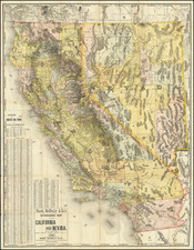
Rare separately issued promotional map of Southern California, published by Rand McNally & Company, one of the earliest maps to focus on Southern California as an economic unit.
The map notes that was compiled and printed by the Horticultural Society of Southern California by W.H. Holabird.
The map is a remarkable complilation of information, including towns, roads, ranchos, railroad lines, mountains, rivers, etc. Includes many early Southern California place names, pre-dating hte creation of Orange County and Riverside County.
The front and the back of the map include extensive promotional information, with the title on the front panels of the map being: Southern California its Attractions and Advantages for small farmers. A collection of facts and figures compiled and printed by the Horticultural Society of Southern California, with a new and carefully compiled map of the Five Southern California Counties.
The Horticulture Society of Southern California functioned as a Chamber of Commerce, promoting immigration to the five southern counties. It stressed the attractions and advantages of scores of California locations for small farms and bombarded West and Midwest with figures, photographs and maps.
The map was published in 1888, one year after a map of similar title, but larger, was published by Rand McNally.
The map is extremely rare. This is the first example of the map we have ever seen. OCLC locates only 2 examples (Bancroft and Huntington).
Rand McNally & Co. is a large American map and navigation company best known for its annual atlases. The company got its start in 1856, when William Rand opened a print shop in Chicago. He was joined in 1858 by a new employee, Andrew McNally. Together, the men established their namesake company in 1868. Originally, the company was intended to print the tickets and timetables for the trains running to and through Chicago; their first railway guide was published in 1869.
By 1870, they had shifted from just printing to publishing directories, travel guides, and newspapers. Their first map appeared in 1872 in a railway guide. The map was produced using a new wax engraving method, a cheaper process that gave the company an edge.
By 1880 Rand McNally had entered the education market with globes, wall maps, and geography texts for students. In 1923, Rand McNally published the first Goode’s World Atlas, named after its editor, Dr. J. Paul Goode. For generations afterward, this would be the standard classroom atlas.
In 1899, William Rand left the company, but McNally and his family remained, controlling the company for over a century. In 1904, they published their first road map intended for automobiles and by 1907 were publishing Photo-Auto Guides, which combined photography and mapping to help drivers. In 1924, they produced the Auto Chum, a precursor to their famous road atlases. Rand McNally would remain the leader in road maps and atlases throughout the twentieth century.
In 1937, Rand McNally opened its first store in New York City. Ever on the frontier of technology, Rand McNally pioneered the scribing process for printing tickets in 1958 and printed their first full-color road atlas in 1960. Arthur Robinson developed his now-famous projection of Rand McNally in 1969. By the 1980s, the company was exploring digital reproduction and digital databases of maps for truckers. In the 1990s, they lead the charge to develop trip-planning software and websites. Today, most of its products are available online or in a digital format, including maps for tablets and phones.
![[Austins Colony] Mexico & Guatemala](https://storage.googleapis.com/raremaps/img/small/94054.jpg)
![[ Highway Symbols! ] Automobile Road Map of California-Nevada Los Angeles and Vicinity Long Beach](https://storage.googleapis.com/raremaps/img/small/99652.jpg)