


|
||

|

|
|

|
Striking full color example of this fine early map of the World, which first appeared in Botero's Theatrum oder Schauspiegel . . . , first published in Cologne in 1596.
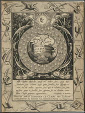
Shirley notes "examples of Andreas' world map are rarely offered for sale."
Lambert's map derives from Mercator's planispheric map of 1569, with the addition of a note on the size of the earth at the top right (5400 German miles) and a quote from Cicero at the bottom. South America includes the large western bulge, as shown in contemporary maps by Mercator and Ortelius. The mythical islands of Groclant, Thule, Frischlant and S. Brandam appear near Greenland. Large Terra Australis Incognita at the bottom of the map, predating the voyages of Le Maire and Schouten which identified the route around Cape Horn--with only the Straits of Magellan showing.
The cartography of Southeast Asia includes references to the mythical lands of Beach and Lucach, based upon Marco Polo, in the general vicinity of Australia, with a note crediting the Venetian for his travels in the region. No sign of the Korean Peninsula. Oddly shaped Japan.
An unusual Northwest coast of America is shown, with clearly delineated Northwest passage and Norheast passage, the former being obscured by two allegorical figures. Classic 16th Century cartographic representation of North America, dominated by the conjectural course of the St. Lawrence River reaching to Texas and the Great Plains.
Quivira, Tolm and Annian appear on the West Coast, along with Cevola.
Several Sea Monsters complete this decorative and scarce map. The Cicero quote at the bottom translates "who can consider human affairs to be great, when he comprehends the eternity and vastness of the entire world?," the same quote added to Ortelius's world map of 1570.
![[17th Century Provenance!] Universalis Tabula Iuxta Ptolemaeum](https://storage.googleapis.com/raremaps/img/small/72635.jpg)
![[Hand Drawn Map of the World]](https://storage.googleapis.com/raremaps/img/small/86629.jpg)
![Western Hemisphere [and] Eastern Hemisphere](https://storage.googleapis.com/raremaps/img/small/77454.jpg)