


|
||

|

|
|

|
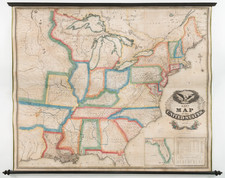
Nice example of the true first edition of Amos Lay's wall map of the United States, first published in May of 1827, the earliest obtainable printed map to include Austin's Settlement.
This example of Lay's map is unique in that it begins the process of blue outline coloring for the major Indian Regions of the US, especially those in Georgia, Mississippi, Alabama and Arkansas. By the next state of the map, the reservation lines would expand to include Michigan, Illinois, Indiana and Missouri. A number of early routes of exploration west of the Mississippi are shown and Texas is named, on the eve of its land boom, with Austin's settlement noted.
Streeter noted that this was the earliest appearance of Austin's Settlement on a printed map, with the exception of a rare Mexico City imprint, known in only one example. Streeter notes that the settlement, likely intended to be San Felipe de Austin, is incorrectly shown on the east bank of the Colorado River. The mythical Presidio of Nacogdoches is shown, not far from the coast between Galveston Bay and the Sabine River. St. Louis Bay is shown at the mouth of the Brazos. Streeter notes the existence of the 1827 and 1830 editions.
![[All The Way With LBJ - 1964 Presidential Election Campaign Poster] Johnson Humphrey for the USA](https://storage.googleapis.com/raremaps/img/small/88907.jpg)
![[Shows Republic of Texas] United States and Texas](https://storage.googleapis.com/raremaps/img/small/101139.jpg)
![[DeWitt Clinton Copy] An Account of Expeditions to the Sources of the Mississippi, and through the Western Parts of Louisiana, to the Sources of the Arkansaw, Kans, La Platte, and Pierre Jaun, Rivers During the years 1805, 1806 and 1807. And a Tour through the Interior Parts of New Spain. in the year 1807.](https://storage.googleapis.com/raremaps/img/small/81745.jpg)