|
||

|

|
|

|
Remarkable Series of Taiwanese Classroom Hanging Maps Covering the Modern History of China
Striking series of maps, The Modern History of China Hanging Map Series [中國近代史挂圖], published in the 1960s in Taipei. The colorful and graphically-compelling maps tell the story of China’s modern history from a Republican perspective from the early Ming Dynasty (1368-1644) to the Second World War.
The map series was published by the Mass Culture Society Publisher [大众文化社出版], a short-lived publisher that specialized in educational materials, under the direction of Taiwan National University Professor Lin Shoukong [林守孔].
Used as teaching aids in Taiwanese schools and universities, the series constructs a narrative of Chinese history that supported the political project of the Nationalist government of Chiang Kai-shek in the 1960s. Overall, the series includes small scale maps, depicting macro-level developments affecting the Middle Kingdom, while two large-scale maps and numerous insets provide local-level details.
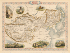
This Map: Russia’s Invasion of China (1689-1949)
This map represents the encroachment by the Russian Empire and USSR into China from the seventeenth through the twentieth century. The most significant elements are the various red features, representing forms of Russian aggression, and territories ceded by China to Russia throughout the period.
The pink region is labeled in the legend as “losses during the Manchu Qing Era.” The orange region is labeled “losses during the Republican Era.” The tan area is provocatively labeled “territories arbitrarily severed by communist bandits [outer Mongolia].” The white box explaining this concession points to the Sino-Soviet Treaty of Friendship (1953), which “gave away our country’s national territory.”
Red arrows represent the movements of invading Russian armies. Cities marked by a red dot are those that were opened to Russian trade through the Treaty of Tianjin (1858). Cities underlined in red were those opened through the Treaty of Peking (1860), at the end of the Second Opium War. Cities double underlined in red were opened through the Treaty of Tarbagatai (1864). Cities outlined with a red box were opened through the Treaty of Saint Petersburg (1881).
Of all the maps in this series, this one may be the most colored by the Cold War atmosphere in which it was published. The Chinese Nationalists, as enemies of the Chinese Communists and close allies of the Americans, were keen to promote anti-Russian sentiment among the people of Taiwan. This map, which exaggeratingly emphasizes all the ways China was victimized by Russia through the centuries, would help Taiwanese schoolchildren contextualize the anti-Soviet propaganda they must have encountered on a day-to-day basis.
Publishing context of the series
The 1960s were a fascinating decade in the history of the Republic of China. Taiwan was on the front line of the global Cold War, and cross-strait relations were tense. The Chinese Nationalist Party, led by an aging Chiang Kai-shek, maintained martial law on the island, and the Modern History of China Hanging Map Series reflects the political climate in Taiwan at the time. The series had to be approved by the Ministry of the Interior, indicated by the registration number given in fine print at the bottom of each map.
Born in Henan on the mainland, Professor Lin Shoukong, the historical advisor to the publisher, fled with the Nationalists to Taiwan in 1949, becoming one of the Republic’s most important intellectuals. He published several textbooks that were standard in Taiwanese schools, and it is likely that teachers used these maps in conjunction with one of these textbooks.
The keystone to the Nationalists’ political project during this period was their assertion that they were the legitimate rulers of all China, and by extension of Taiwan’s education system, and these maps in particular served to inculcate this notion in the minds of students.
Viewed in sequence, the series begin at the ethnically Han Chinese Ming Dynasty’s high point, with an inset depicting Zheng He’s Voyages throughout the South China Sea and Indian Ocean. The fall of the Ming and the rise of the Qing make up the second sub-section of maps. A majority of the maps depict developments during China’s “Century of Humiliation” (1839-1945), when weak, ethnically Manchu rulers allowed foreign powers to chip away at Chinese sovereignty leading to fragmentation and immiseration of the once-mighty Chinese empire. The final maps in the series depict the rebirth of China under Sun Yat Sen and the heroic defense of the nation against Japan by the Nationalists under Chiang Kai-shek, omitting the victory of the Communists in the Chinese Civil War.
The sequence implies a teleology in which the Han people, brought low for centuries by foreign oppression, would regain control of the Middle Kingdom. The maps thus reinforced the founding myth of the Chinese Nationalist Party in the minds of students facing the political uncertainties of 1960s Taiwan.
These maps are remarkable artifacts from a short-lived publishing house. They reflect an important period in Chinese and Taiwanese history.
Rarity
As these maps were ephemeral and used in a classroom setting, their survival is uncommon. We have located only three complete sets, two in Taiwan schools and one in the National Library of Australia.
Modern History of China Hanging Map Series
Striking series of maps, The Modern History of China Hanging Map Series [中國近代史挂圖], published in the 1960s in Taipei. The colorful and graphically-compelling maps tell the story of China’s modern history from a Republican perspective from the early Ming Dynasty (1368-1644) to the Second World War. The map series was published by the Mass Culture Society Publisher [大众文化社出版], a short-lived publisher that specialized in educational materials, under the direction of Taiwan National University Professor Lin Shoukong [林守孔]. Used as teaching aids in Taiwanese schools and universities, the series constructs a narrative of Chinese history that supported the political project of the Nationalist government of Chiang Kai-shek in the 1960s. Overall, the series includes small scale maps, depicting macro-level developments affecting the Middle Kingdom, while two large-scale maps and numerous insets provide local-level details.