


|
||

|

|
|

|
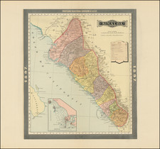
An extremely rare and important map of Baja California, specially prepared for the legendary 'Filibuster', William Walker.
This fascinating map is a rare artifact from an especially dramatic and unusual event in the history of Mexico and the American West. It focuses on the Peninsula of Baja California, which during the years following the Mexican-American War (1845-48), was the focus of fevered speculation and political intrigue. In 1853, the American 'Filibuster', William Walker, led a small military expedition that succeeded in briefly seizing control of Baja's capital of La Paz. Walker declared the peninsula to be a "New Republic", independent from Mexican sovereignty, and under his personal rule.
The present map was evidently commissioned by Walker as a rhetorical device to establish and defend his proclamation of the Republic, and is importantly the only contemporary printed map to portray his designs. The map features the entire Peninsula of Baja California, up past the U.S. border to include San Diego. Among the more curious features is the location of "Lopez", just south of San Diego. While it would be tempting to say that this is Casa de Lopez, it is more likely the large Vineyard operated by Don Jose Lopez.
The map also includes the Mexican states of Sinaloa and Sonora, showing the northern border of the latter extending northwards to the Gila River, then the international boundary between Mexico and the United States, before it was moved southward following the ratification of the Gadsden Purchase in 1854 (and therefore including Tuscon, Arizona). Topographic relief is expressed through hachures; numerous towns are labeled, along with the various crude roads that connected the settlements. Virtually all of the text is presented in English, true to Walker's designs to create an Anglo-American Republic in Mexico.
Historical Context
Following the Mexican-American War, the United States had vastly expanded its territory, while numerous American speculators had made great fortunes through events such as the California Gold Rush. Not surprisingly, certain American adventurers turned their gaze even further southwards to see what other riches could be prized from Latin America. Some of the more ambitious of these figures even harbored designs to invade parts of Mexico and Central America, with the objective of establishing new American-allied republics. This imperialist act of nation-building was termed 'filibustering'.
By far the most prominent filibuster was William Walker (1824-60). Born in Nashville, he was both a physician and lawyer and was famed for his charm and wit, but also for his grandiose ambition and almost complete recklessness. An ideological American imperialist and supporter of slavery, his schemes were intended to advance these ends.
Walker travelled to San Francisco in 1849, hoping to make a fortune in the Gold Rush. While in California, he learned that Sonora and Baja California, which remained possessions of Mexico, were rich in gold and silver, yet lightly populated and poorly defended. Walker at first applied to the Mexican government for permission to establish a colony in Sonora, an application that was wisely declined.
Undeterred, Walker believed that seizing control of Baja and Sonora by force could be accomplished with relative ease. Furthermore, once this was accomplished, he was confident that the prevailing pro-expansionist sentiment within the United Stares would quickly lead to official American support for his enterprise. Walker recruited a rag-tag group of supporters of slavery and the Manifest Destiny Doctrine (mostly from Kentucky and Tennessee), to establish an independent republic in Mexico, which might ultimately become a slave-holding state in the United States, in the same fashion as the Republic of Texas.
In the Summer of 1853, Walker and his supporters invaded and conquered La Paz, the capital of Baja California. There, Walker declared himself the President of the Republic of Baja California, establishing his capital in Ensenada. However, his efforts to take Sonora (and create the Republic of Sonora) failed and he was soon forced out of Mexico altogether.
Far from being supportive of Walker's endeavors, the U.S. Government, which was then negotiating the Gadsden Purchase with Mexico, believed Walker to be loose-cannon and a political liability. He was tried in federal court in San Francisco for conducting an illegal war under the Neutrality Act of 1794. However, his actions were widely popular in America, and a jury took only eight minutes to acquit him of all charges.
Walker would later conduct a similar (and briefly successful) filibuster in Nicaragua in 1856, before his attempts to take over Honduras resulted in his execution in 1860.
The Map of the New Republic
The present map predates J. Ross Brown's Map of Lower California from Special Surveys of the Coast and Interior (1868), which was intended to aid American speculators in the region. While clearly commissioned by Walker, little is known about the creation of this map, other than an entry in the Clifford Sale Catalog stating: "This letter sheet was part of the effort to fund William Walker's first filibuster expedition. . . .".
The following entry appeared as item #193 in Anderson Galleries sale # 1686 (November 22, 1922), entitled A Great Collection of Original Source Material Relating to the Early West and The Far West:
MAP OF THE "NEW REPUBLIC" OR WALKER'S CALIFORNIA FILIBUSTER KINGDOM. 1853
193. CALIFORNIA. Walker (Gen. William). Map of the New Republic: Embracing Lower California, Sonora and Cinaloa, with parts of California and New Mexico; Showing the Routes, Towns, Topographical Features of the Country, &c. (With Flag of the Republic in corner.) Lithograph 91/2 by 8 inches.
Lith. Britton & Rey., San Francisco, [1853]
Apparently the ONLY KNOWN copy. Not in Bancroft. Its historical importance as a pictorial record of one of the most amazing attempts at territorial acquisition in the early annals of California needs no emphasis. Walker and his band of California recruits sailed down the Coast, capturing La Paz, where the Governor was seized and the New Republic proclaimed. The victory aroused wild enthusiasm in San Francisco, her editors extending their welcome to the New Republic into the sisterhood of states; and numbers of the population enrolled for glory and plunder in the Colorado desert. The "Republic" endured from Nov. 3, 1853 to May 8, 1854, when the U.S. Army took a hand in the proceedings.
The map is of the utmost rarity. With the last auction records in Americana Exchange are Streeter in 1969 and Anderson Galleries in 1922. We note only 3 institutional examples (Bancroft (acquired after the Anderson sale), Arizona Historical Society and Principia College).
![[Esparto, California] Map Showing Subdivisions of the Bonynge Tract and the Position of the Townsite of Esperanza Yolo County California... 1887-1888](https://storage.googleapis.com/raremaps/img/small/83457.jpg)
![[Northern California] North Bay Horse Country](https://storage.googleapis.com/raremaps/img/small/86802.jpg)
![(Texas - Mexican War) Campaña Contra Los Americanos del Norte. Primera Parte [all issued]. Relación histórica de los Cuarenta Días que mandó en gefe el ejército del Norte el E. Sr. general de division Don Mariano Arista, Escrita por un oficial de infantería](https://storage.googleapis.com/raremaps/img/small/95742.jpg)