|
||

|

|
|

|
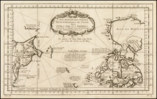
Old color example of the first state of this detailed 2-sheet map of Canada and its North Polar regions, published by Pierre Mortier.
The map extends north to Baffin's Bay, west to Buttons Bay and the Straits of Anian and east to Iceland and Greenland.
The map includes the Straits of Anian at the lower left corner, suggesting the prospect of a Northwest Passage to Buttons Bay.
Pierre, or Pieter, Mortier (1661-1711) was a Dutch engraver, son of a French refugee. He was born in Leiden. In 1690 he was granted a privilege to publish French maps in Dutch lands. In 1693 he released the first and accompanying volume of the Neptune Francois. The third followed in 1700. His son, Cornelis (1699-1783), would partner with Johannes Covens I, creating one of the most important map publishing companies of the eighteenth century.
![[Spitzbergen & Wiches Lande]](https://storage.googleapis.com/raremaps/img/small/61990.jpg)