


|
||

|

|
|

|
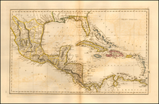
Decorative example of TC Lotter's decorative adaptation of De L'Isle's important map of 1703.
The map provides a view of North America from the Great Lakes through the West Indies. The British colonies are confined east of the Appalachian Mountains, France controls the Mississippi valley and Florida, and Spain possesses Mexico and New Mexico. Political divisions as dictated by the Treaty of Utrecht in 1713. While geographically nearly identical to De L'Isle's chart, this map is very decorative with the lower left corner filled with a huge sea battle and the Atlantic filled with four inset plans of Panama, Havana, Carthagena and Vera Cruz. The details of the Mississippi Valley were the most radical departure from earlier maps, accurately depicting the information provided by the French Jeusuits in North America in the late 17th Century. Nice detail along the Rio Grande and in Texas. Richly annotated with information regarding the Spanish activities in the Gulf of Mexico.
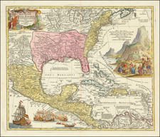
Nice example of this desireable map, which had first been issued by Seutter.
Tobias Conrad Lotter (1717-1777) is one of the best-known German mapmakers of the eighteenth century. He engraved many of the maps published by Matthaus Seutter, to whose daughter Lotter was married. He took over Seutter’s business in 1756. Lotter’s son, M. A. Lotter, succeeded his father in the business.
![[ Gulf Coast & West Coast of Florida ] De Cust van Westindien Van La Desconoscida, tot C. Escondido. . .](https://storage.googleapis.com/raremaps/img/small/65741.jpg)