


|
||

|

|
|

|
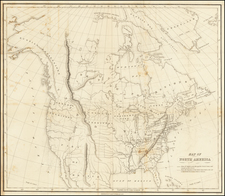
Scarce map of the United States, showing a number of early and transitional territorial configurations, including the newly formed Mississippi Territory.
The map shows the disputed parts of Mississippi Territory (Spansih West Florida etc.) ambigously. Indiana Territory is directly below Lake Michigan, with Illinois Territory pushed far west of its true location, with no attempt to reconcile the location of Chicago on Lake Michigan.
Mississippi Territory is shown and includes Alabama. Misconfigured Ohio and and Michigan Territories. Louisiana is shown, as is the former Neu Orleans territory, which briefly existed during the Spanish and French control of the region. Masive Missury Territory.
Excellent detail, including forts, Indian Tribes, and other interesting details. Nice detail in Florida.
Johann, or Johannes, Walch (1757-1816) was a painter and engraver. He was well-known for painting miniature portraits, having trained in Geneva, Venice, and Rome. Walch published several atlases and sheet maps. As with his atlases, many of Walch’s maps were reprinted after his death.
![[French America and the Triangular Trade] L'Amérique Françoise Où son Décrites La France Nouvelle, La France Insulaire, La France Equinoctiale, et autre pais Par P. Du Val d'Abbeville Geographe du Roy . . .](https://storage.googleapis.com/raremaps/img/small/91968.jpg)
![A New and Exact Map of the Dominions of the King of Great Britain on ye Continent of North America . . . [Beaver map]](https://storage.googleapis.com/raremaps/img/small/101277.jpg)
![[German Northern Pacific Promotional Tract] Die Nordliche Pacific Eisenbahn; Ihre Route, hulfsquellen, fortschritte & Gefchafte. der neue Nord-Westen und seine grosse Verkehrs-Strasse.](https://storage.googleapis.com/raremaps/img/small/83777.jpg)