


|
||

|

|
|

|
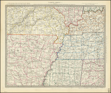
Marvelous regional map, showing the early counties, towns, roads and Indian details. The counties of Arkansas are still largely incomplete. Northern Mississippi is dominated by Chiasawaw and Choctaw lands. Missouri's counties are largely incomplete and unnamed, with a massive Wayne County running for nearly half the length of the Territory. Interesting Indian Information and forts throughout the map. Little Rock or Acropolis appears in Pulaski County. Based in part of information derived from Henry Schenk Tanner, who receives credit in the lower left corner of the map. Information key notes abbreviations for Bridges, Court Houses, Churches, Creeks, Forks, Lakes, Mountains, Post Offices, Points, Springs, Swamps & Villages, Indian Villages, Forts, etc.
![Factors of Prosperity in the Rock Island-Frisco States of America [cover title]](https://storage.googleapis.com/raremaps/img/small/94604.jpg)
![[The First Maps Printed Color] Cartes en Couleur des Lieux Sujets aux tremblements de Terre Dans toutes les parties du Monde Selon le Sisteme de l’impulsion Solaire](https://storage.googleapis.com/raremaps/img/small/52293op.jpg)