


|
||

|

|
|

|
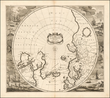
Fine example of the first edition of this important map of the Northern Hemisphere, published by Guillaume De L'Isle in 1714.
This map would become the proto-type for a number of other 18th Century maps of the Northern Hemisphere and would be re-issued by De L'Isle and his heirs for the next 70 years.
Cartographically, this means of projection has the opposite effect of the Mercator projection. The Mercator projection inflates land masses at the northern and southern extremes while showing regions closer to the Equator correctly. This projection shows the Polar regions correctly and distorts Equatorial lands.
California is shown as a peninsula. Japan is still in a fairly early stage of cartography, and the northeast coast of Russia has not yet been charted out to its full extent. However, it is the blank spaces that show one of the major steps achieved here; De L'Isle is little given to speculation about what has not been proven by actual exploration. His approach is emblematic of the more scientific approach taken in cartography during the 18th Century.
A fine wide margined example of this first state of the map, which would be copied, re-issued and updated for nearly a century.
Guillaume De L'Isle (1675-1726) is probably the greatest figure in French cartography. Having learned geography from his father Claude, by the age of eight or nine he could draw maps to demonstrate ancient history. He studied mathematics and astronomy under Cassini, from whom he received a superb grounding in scientific cartography—the hallmark of his work. His first atlas was published in ca. 1700. In 1702 he was elected a member of the Academie Royale des Sciences and in 1718 he became Premier Geographe du Roi.
De L'Isle's work was important as marking a transition from the maps of the Dutch school, which were highly decorative and artistically-orientated, to a more scientific approach. He reduced the importance given to the decorative elements in maps, and emphasized the scientific base on which they were constructed. His maps of the newly explored parts of the world reflect the most up-to-date information available and did not contain fanciful detail in the absence of solid information. It can be fairly said that he was truly the father of the modern school of cartography at the commercial level.
De L’Isle also played a prominent part in the recalculation of latitude and longitude, based on the most recent celestial observations. His major contribution was in collating and incorporating this latitudinal and longitudinal information in his maps, setting a new standard of accuracy, quickly followed by many of his contemporaries. Guillaume De L’Isle’s work was widely copied by other mapmakers of the period, including Chatelain, Covens & Mortier, and Albrizzi.