|
||

|

|
|

|
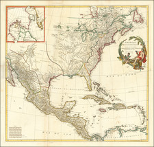
Nice example of the 1832 edition of Brue's map of Map of North America, described at length by Wheat in his seminal book on the Mapping of the Transmississippi West (Wheat 335).
The map is a marvelous post-Lewis & Clark production, combining excellent detail from the expedition in the Northwest with information from Pike, Humboldt and others. The Phillipe ou Rio del Colorado flows from Monterey to Both Lake Teguayo and Timpanago and then onward even further toward the Rocky Mountains. Excellent detail in Texas.
The map includes remarkable Indian details. The Missions of Upper California are named. The Rocky Mountains are shown as a single Cordillera, as described by Humboldt. Excellent detail in Western Canada and Russian America. This 1832 edition includes a 54-40 or Fight Oregon Territorial border.
The first edition of this map (1821--unknown to Wheat) is rare on the market, with no example being offered in a dealer catalogue in over 10 years. This 1832 edition is also quite rare.
Many changes have been made between the two editions, primarily in the Arctic Ocean and northern portions of the map. The Arctic Coastline of Amerique Russe (Alaska) is now complete and the boundary with Nouvelle Bretagne is set at 142 degrees and referred to as "Nouvelle Limite", rather than the curious unnamed curve shown on the earlier edition. The Arctic Ocean of Canada is also far more complete, with new place names and annotations, whereas the earlier edition showed only the areas around the discoveries of Mackenzie and Hearne at the mouths of the two rivers discovered by these explorers. There are also extensive revisions in around Hudson's Bay and Hudson's Strait, etc.
Interestingly, California and Oregon Territory are largely unchanged between editions, other than the revision of the Oregon-Nouvelle Bretagne Border, which is decidedly pro-American/Anti-English.
A fine example of this rare 2-sheet map.
Andre Hubert Brué was a French geographer and cartographer. Born in Paris, he served in the French Navy, joining the Baudin expedition to the Pacific (1800-1804). After his sea service, Brué applied his navigation and charting skills to creating finely-crafted maps, which were renowned for their crisp engraving and accuracy. He drew directly on the copper of the plate, creating what he called encyprotypes. He is best known for the Atlas universal de géographie physique, politique, ancienne et moderne.

![[Pan American Menu Map] North America](https://storage.googleapis.com/raremaps/img/small/103976.jpg)