


|
||

|

|
|

|
Exceptional example of first edition of Shetlon & Kensett's rare map of the United States, bound in its original covers, in full original color.
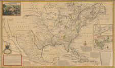
Shelton & Kensett's map of the United States, with its spectucular cartouche engraved by Amos Doolittle, is among the rarest and most soughtafter maps of the United States published in the early part of the 19th Century.
The map was engraved by Thomas Kensett, the cartouche, with a large image of Niagara Falls was engraved by Amos Doolittle. Cartographically, this map is far superior to either the Arrowsmith or Tardieu maps: in the west it incorporates both of Pike's maps of the Upper Mississippi and the western tributaries of the Mississippi and the Missouri; east of the Mississippi, it uses much from the Bradley "Postal" map of the United States of 1804-1812, including public survey lines, county formations, township boundaries, roads, etc. There are two very interesting inset maps and a commentary on ancient fortifications found along the Ohio River.
Rumsey states: "This highly detailed and accurate map must be one of the best of its period."
Issued in the same year as John Melish's land mark coast to coast Map of the United States with the Contiguous British & Spanish Possessions," Shelton & Kensett's map was apparently not a commercial success and as a result is extremely rare, and only a small handful known to exist. There is only one state recorded, although Harry Newman of the Old Print Shop reports having seen fragments of an example that suggest that an 1817 edition was issued, showing Alabama Territory.
The firm of Shelton & Kensett was founded circa 1812 in Cheshire, Connecticut. They issued a number of maps and pints, many of which are quite scarce. Thomas Kensett (1786-1829) was born in England and emigrated to America. He was in New Haven in 1806. Amos Doolittle (1754-1832) was born in Cheshire, Conn. And was trained as a jeweler and silversmith. As an engraver, he was self-taught. He produced a number of engravings by himself, with his son and with the firm of Shelton & Kensett.
Shelton & Kensett identify the sources for the small pictures in the lower corners of their huge map of the United States and Canada. The inscription accompanying the cartouche states that "This view of the Falls of Niagara is Engraved from Tardieu's Map Published in Paris." A "Plan and Description of an Ancient Work" is credited to "Mr. Enos Cutler, Deputy Surveyor," and the "Plan of the Ancient Works at Marietta" was taken by "the Hon. Gen. Parsons and Communicated to the Rev. Doctor Stiles President of Yale College."
An exceptional example of this important early wall map of the United States.

![[Hand Drawn Map] Le Golfe de Mexique avec les Pays Circonvoisins](https://storage.googleapis.com/raremaps/img/small/91580.jpg)