|
||

|

|
|

|
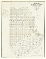
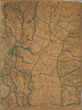
Rare separately issued chart of "Upper San Francisco Bay," published by the United States Coast Survey in 1862.
The most northerly point on the map is Pt. Avisadero, just north of Candlestick Point and extending south to San Jose. The chart provides a rough outline of the shoreline, with some internal details, especially along the shoreline in the southern part of the map. Early place names include Aviso, Long Point, Ravenswood, Mayhew's Landing, Mowery's Landing, Redwood City, Belmont, Marsh Point, Guano Island, Pt. San Mateo, Pt. San Bruno, Sierra Pt., Pt. Avisadero, Thompson's Landing, Eden's Landing, Allen's Landing, Union City, and Johnson's Landing.
The chart is substantially similar to the chart which appeared in the US Coast Survey's official report, but lacks the credit in the lower right corner, referencing "Lith of C. Knickerbocker, Albany, N.Y."
These separately issued USCS charts are extremely rare, this being the first example of this chart we have seen on the market.
The United States Office of the Coast Survey began in 1807, when Thomas Jefferson founded the Survey of the Coast. However, the fledgling office was plagued by the War of 1812 and disagreements over whether it should be civilian or military controlled. The entity was re-founded in 1832 with Ferdinand Rudolph Hassler as its superintendent. Although a civilian agency, many military officers served the office; army officers tended to perform the topographic surveys, while naval officers conducted the hydrographic work.
The Survey’s history was greatly affected by larger events in American history. During the Civil War, while the agency was led by Alexander Dallas Bache (Benjamin Franklin’s grandson), the Survey provided the Union army with charts. Survey personnel accompanied blockading squadrons in the field, making new charts in the process.
After the Civil War, as the country was settled, the Coast Survey sent parties to make new maps, employing scientists and naturalists like John Muir and Louis Agassiz in the process. By 1926, the Survey expanded their purview further to include aeronautical charts. During the Great Depression, the Coast Survey employed over 10,000 people and in the Second World War the office oversaw the production of 100 million maps for the Allies. Since 1970, the Coastal and Geodetic Survey has formed part of the National Oceanic and Atmospheric Administration (NOAA) and it is still producing navigational products and services today.