|
||

|

|
|

|
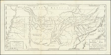
Interesting pair of maps showing towns that were never built in the present-day state of Kentucky.
Franklinville located in Mason County, was formed on paper in 1794 by a group of London speculators. The town was to be built beside the North Fork of the Kentucky River on plans drafted by a London engineer. It reflected the aspirations of the time in the classical precision of its plan. Seventy six squares were to be developed about a central park. There was to be a college, a church, a theater, and a town hall.
Lystra, located in Nelson County, was formed on paper in 1794 by a group of London speculators. The town was to be built beside the South Creek of the Rolling Fork of the Kentucky River on plans drafted by a London engineer. It reflected the aspirations of the time in the classical precision of its plan. 25 Blocks and 188 Lot squares were to be developed around a central park. There was to be a college, a church, a theater, and a town hall.
Two of the earliest printed American Town Plans.

![(Southern Travel Journal) [Manuscript travel journal to Mobile, Alabama by Andrew Clark, Jr. of Methuen, Massachusetts, also by horseback through Kentucky and Tennessee and up the Mississippi north to Pittsburgh]](https://storage.googleapis.com/raremaps/img/small/93034.jpg)