|
||

|

|
|

|
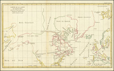
First edition of this rare and fascinating large-format map of the North Polar regions, depicting the progress of Arctic exploration up to 1895.
At the end of the 19th-century the two polar regions remained the World's final frontiers of exploration. While most of the lands within the Artic Circle had been explored by this time, as the map shows, significant areas of Canada's Arctic Archipelago and northeastern Greenland remained complete enigmas. Even more important was the race to become the first person to reach the North Pole, which by the 1890s had developed into a heated competition with strong nationalistic overtones. While the pole would not be reached until 1926 (by Roald Amundsen), a few explorers had already come relatively close and global bragging-rights centered on whom had thus far reached the highest latitude.
Critically, the present map, perhaps more than any other production, was the most copiously detailed overview of Arctic exploration published to the time. The map embraces the Arctic regions of the globe above 62° 30'N. The shorelines colored in a variety of hues, are described in the "Explorations of Coasts" legend (in the lower right) which identifies the coastlines encountered by dozens of explores from Semion Chelyushkin's discoveries in Siberia in 1741-2 to Robert Peary's Greenland expedition of 1895. Likewise, dozens of "Tracks of Expeditions" line the map, ranging from Robert McClure's expedition to Canada in 1850 to Robert Peary's Greenland expedition of 1892. Notably these voyages not only included expeditions of discovery, but also search and rescue missions aimed at the many exploring parties that had gone missing, a clear reminder of the extreme dangers of early Arctic discovery.
A curious, and indeed controversial aspect of the map is the "Circle of Latitude passsing through the nearest approach to the Pole", referring explicitly to the American expedition of Lt. James B. Lockwood and David L. Brainard, which achieved a new "furthest north" record of 83° 23'8" in May 1882. While this record stood for some years, by the time this map was made, it was widely regarded that the Danish expedition under Fridtjof Nansen broke that record on April 3, 1895 by reaching 86° 13.6'N. However, the map makes no reference to Nansen's endeavor.
It appears that this 'mistake' was intentional. With national pride at stake, the American government and media did not want to admit that Nansen had broken the Americans' record. A New York Times aritcle entitled "Artic Exploration Described", dated April 23, 1896 focuses on the present map. It reads that "The recent revival of interest in Arctic exploration" caused the U.S. Navel Hydrographic Office to produce the "carefully prepared map" in an effort to despel the "unfounded Nansen rumors". This being conceded the map nevertheless provides a wealth of accurate information on the nature of progress of Arctic exploration. A second edition of the map was issued in 1897.
The present map is exceptionally rare, and we are not aware of any examples of either the 1896 or 1897 edition appearing in dealer catalogs or at auction going back more than 30 years.
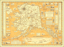
![[ Routes to the Gold Regions ] Explorations in Alaska 1899 Route From Lynn Canal Via Headwaters of White and Tanana Rivers to Eagle City](https://storage.googleapis.com/raremaps/img/small/98762.jpg)
![[Russian Alaska] Меркаторская Генеральная Карта, части Российскихъ Владеній въ Америкѣ (Mercator's [or Mercatorial] General Map, parts of Russian Possessions in America)](https://storage.googleapis.com/raremaps/img/small/55959.jpg)
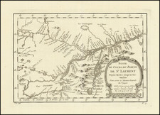
![[ Mount St. Elias to Prince Wiliam Sound, Chiswell Island, etc. ] A Chart Shewing Part of the Coast of N.W. America, with the Tracks of His Majesty's Sloop Discovery. . .](https://storage.googleapis.com/raremaps/img/small/88067.jpg)