|
||

|

|
|

|
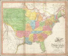
Striking map of North America, issued shortly after Henry Popple's seminal map of North America, upon which this map is based.
This map has created a fair amount of discussion in recent years. While the map is known to have appeared in Salmon's Modern History, various dealers and historians have attributed the map at different times to Salmon, Williamson, Stephens and Osborne, with dates varying from the mid 1730s to 1755.The consensus of opinion is that the map is based upon Henry Popple's seminal map of North America, one of the two most important large format English maps of the 18th Century (along with the John Mitchell map). We have observed that there are at least 2 editions of the map, one with a binding reference to vol 3, p.425 in the upper left corner, the other without.
The map is a marriage of important early cartographic information and a wonderfully clean and elegant engraving style. The map shows most of Lake Superior and Lake Illinois (Michigan) and extends nearly to the confluence of the Ohio and the Mississippi. In Central Tennessee, a note appears identifying a Fit Place for an English Factory. The Illinois, Hohio and Pelesipi Rivers are named west of the Appalachean Mountains. Georgia is named, along with the Charokees N[ation]. Annapolis T. appears in Maryland. A Keaniee village appears at the headwaters of the Podee River in North Carolina. In Western New York, the Cayagas, Onondages, Senekas, Iroquis and Mohawkes are named, alont with the Mowhawk River and Ft. Oswego. A number of early English forts appear, including Ft. Anne, Ft. Nicholson, & Ft. Sorel. Province of Main and New Hampshire are shown. Elizabeth T., New Haven and Perth are named.