|
||

|

|
|

|
Stock# 36277dp
Description
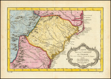
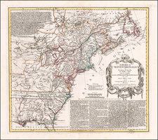
Interesting map of the United States with large inset of the South Carolina and Georgia.
The map extends east to include the confluence of the Kentucky and Ohio Rivers and names Kentucky, but not Ohio or Tennessee. Includes nice detail in the Trans-Appalachian and Trans-Allegheny regions and includes Weld's route through Virginia. Wesern Territory is showns below a Lake Erie, including the names of a number of early Indian Settlements.
The map shows the route of Isaac Weld through the United States.
A note in the upper left corner identifies the regions in which the Christian Indians reside. An interesting 18th Century map of the United States.
![[Uncut promotional broadsides for ] Map of the Surface-Feeding Ducks, Swans and Geese of North America](https://storage.googleapis.com/raremaps/img/small/92052.jpg)