|
||

|

|
|

|
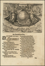
Unrecorded 1680 edition of Michel-Antoine Baudrand's rare double hemisphere world map, first published in Rome in 1658 by Giovanni Giacomo Rossi.
This exceptional double hemisphere world map is one of the few known cartographic works attributed to Michel-Antoine Baudrand, who served as the Royal Geographer to the King of France. As noted by Rodney Shirley, while Baudrand is noted to have published a number of important academic works, he was not generally known as a cartographer.
Rodney Shirley notes:
The map has a large ornate cartouche with a dedication to Cardinal Azzolini. The outer border cotnains two celestial spheres, two polar projections and two circular wind diagrams. For the geographical features Baudrand has drawn principally on Sanson's cartographic work to assimilate all the discoveries of the time. The extensive Iesso north-west of the island of California is shown, with tentative coastline, other than the area supposedly reached by Vries north of Japan in 1643. In North America three of the Great Lakes are given their present-day names, -- Lakes Superior, Huron and Erie -- whilst two others are named as S. Luigi and Pazzolente, In the Pacific, New Guinea is outlined more correctly and placed separate from the Australian continent (called Nova Olandia) which is drawn less accurately than Blaeu and only shown in part. New Zealand is erroneously stated as having been discovered in 1654, instead of 1644. Traces of the old Coastline of Quir and Terra Australe remain.
In spite of the imperfections, Baudrand's map is a finely-engraved example of serious cartographical work. Partly because of its large size and the lack of any standard Italian atlases, it circulation was quite small and relatively few copies are known.
The present example, dated 1680, is unrecorded. This is the only example of any edition of the map we have ever seen on the market.
![[Terrestrial Globe Gore] and [Celestial Globe Gore]](https://storage.googleapis.com/raremaps/img/small/91969.jpg)
![Tabula Terre Nove [The Admiral's Map]](https://storage.googleapis.com/raremaps/img/small/81714.jpg)