|
||

|

|
|

|
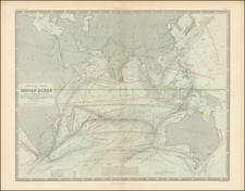
Large 19th Century Sea Chart of the Indian Ocean and Western Pacfiic, extending from China and New Zealand in the East to Africa in the West.
The map includes extensive sailing notes and evidence of early use at sea. Extensive annotations with Australia, along with delineations of Queensland, New South Wails, South Australia, North Australia and Western Australia.
James Imray was a publisher specialized in nautical charts. He started one of the most successful blue-back chart-selling companies of the nineteenth century; it is still in business today. Imray’s father was a dyer and he was born in Spitalfields, London, an area known for its garment industry. James did not want to enter the garment trade, however, and instead apprenticed to Stationer William Lukyn in 1818. Imray began his business as a book publisher and seller; however, he shared premises with Robert Blachford, a chartseller. Imray entered into business with Robert’s successor, Michael. He turned the business into a success and bought Blachford out in 1846, publishing under the imprint of James Imray. In 1854, son James Frederick joined as a partner and the imprint changed to Imray & Son. They thrived thanks to targeted marketing and excellent compilation charts that focused on trade routes. The busines entered in a long decline after the death of James Sr. in 1870. In 1899, Imray & Son amalgamated with Norie & Wilson. This conglomerate was bought by the Laurie firm in 1904 and today the business trades as Imray, Laurie, Norie & Wilson.