|
||

|

|
|

|
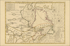
First edition of George Eldridge's rare chart of Vineyard Sound, the first large format printed map of the Vineyard, accompanied by a rare first edition of Eldridge's Pilot pamphlet.
A rare pairing of Eldridge's second published chart with the accompanying pamphlet of sailing directions.
Eldridge's mammoth chart of Vineyard Sound depicts in detail the waters around the Elizabeth Islands, Martha's Vineyard, Nantucket and Monomoy. Hundreds of soundings are given, along with notations about shoals and other hazards, lighthouses and other aids to navigation, sailing directions, &c. Several notes describe the areas tides, currents and compass variations, and a variety of symbols indicate sunken and exposed rocks, currents and sailing lines, and submerged wrecks (The number of wrecks around Monomoy is particularly striking.) Consistent with Eldridge's other work, the whole is executed in a style that, while attractive, is functional and free of unnecessary information or adornment.
As noted by Guthorn:
Although based upon the official Coast Surveys, the Eldridge charts were unsubsidized and more expensive. They survived because of good design, simplicity, omission of extraneous shore topography, legible sounding and notes, and the use of compass courses only.… Their loyal public, fishermen, coaster, tug masters, and yachtsmen, often continued to use obsolete Eldridge charts until the beginning of World War II
Though designed for heavy use, this example's relatively superb condition suggests that it was well loved and/or saw little service at sea. Around 1865, Eldridge replaced this chart with the new Chart of the Vineyard Sound and Nantucket Shoals, which extending coverage well into the Atlantic but was executed at a much smaller scale.
The chart is accompanied by a copy of Eldridge's Pilot for Vineyard Sound and Monomoy Shoals. Both the chart and pamphlet are rare, with OCLC recording but one example of the chart and 5 of the pamphlet. Antique Map Price Record lists no examples of the chart appearing for sale in the past 30 years. Americana Exchange lists two copies of the pamphlet, the most recent offered in 1988 by Edward Lefkowicz for $950. It is extraordinary to encounter these very rare items together and in such excellent condition.
The firm of Eldridge
George Eldridge (1821-1900) of Chatham produced his first chart (of the Chatham area) in 1851 and over more than four decades issued numerous charts and pilot books covering the coast from New York to Maine. Guthorn notes:
[Eldridge] had gone to sea with his fisherman father at an early age, and continued as a fisherman, coaster and local pilot, until an injury at sea in 1850 forced his convalescence ashore. He observed the effects of a new inlet which was formed during a furious storm in april 1851, creating new and dangerous shoals, in the path of vessels. He explored and sounded the new bar in his dory and drew a chart which was lithographed by Tappen [sic] & Bradford in Boston, [which] was an immediate success. Encouraged, he compiled a Chart of Vineyard Sound…
Eldridge's son George W. (1845-1914) later took over the business, and the family firm continued issuing charts through 1932. Though under new ownership, the Eldridge Tide and Pilot Book is published to this day.
Condition: Chart superb, with only minor staining and creasing. Pamphlet dog-eared, with some staining to front wrap and preliminaries.