


|
||

|

|
|

|
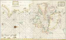
A detailed, large-scale sea chart of the eastern approaches to Hong Kong Harbour issued by the British Admiralty, including most of Hong Kong Island, Kowloon and the western part of the New Territories.
Printed during World War I, the present chart was the authoritative pilot for ships approaching Hong Kong Harbour from the eastward. In 1915, Hong Kong was a rapidly growing city of over 500,000 inhabitants and was already the leading freeport of Asia and the most important base of the Royal Navy in the western Pacific.
The map embraces the eastern three-quarters of Hong Kong Island from Central and Aberdeen eastwards and includes all of Kowloon. The seas include innumerable bathymetric soundings and the markings of navigational hazards, while lighthouses and becons are heightened in red. To the norheast is Mirs Bay (Tai Pang Wan), a large deepwater harbour. In 1898, the bay was famously the Asian marshalling point for American Admiral George Dewey's successful invasion of Manila, Philippines during the Spanish-American War.
The present chart is very rare, and this is the first example we have encountered in 20 years in the business. As such charts were heavily used by both naval and merchant mariners, their survival rate is very low, and this example is in exceptionally fine condition.
The British Admiralty has produced nautical charts since 1795 under the auspices of the United Kingdom Hydrographic Office (HO). Its main task was to provide the Royal Navy with navigational products and service, but since 1821 it has also sold charts to the public.
In 1795, King George III appointed Alexander Dalrymple, a pedantic geographer, to consolidate, catalogue, and improve the Royal Navy’s charts. He produced the first chart as the Hydrographer to the Admiralty in 1802. Dalrymple, known for his sticky personality, served until his death in 1808, when he was succeeded by Captain Thomas Hurd. The HO has been run by naval officers ever since.
Hurd professionalized the office and increased its efficiency. He was succeeded by the Arctic explorer Captain William Parry in 1823. By 1825, the HO was offering over seven hundred charts and views for sale. Under Parry, the HO also began to participate in exploratory expeditions. The first was a joint French-Spanish-British trip to the South Atlantic, a voyage organized in part by the Royal Society of London.
In 1829, Rear-Admiral Sir Francis Beaufort was appointed Hydrographer Royal. Under his management, the HO introduced the wind force scale named for him, as well as began issuing official tide tables (1833). It was under Beaufort that HMS Beagle completed several surveying missions, including its most famous voyage commanded by Captain FitzRoy with Charles Darwin onboard. When Beaufort retired in 1855, the HO had nearly two thousand charts in its catalog.
Later in the nineteenth century, the HO supported the Challenger expedition, which is credited with helping to found the discipline of oceanography. The HO participated in the International Meridian Conference which decided on the Greenwich Meridian as the Prime Meridian. Regulation and standardization of oceanic and navigational measures continued into the twentieth century, with the HO participating at the first International Hydrographic Organization meeting in 1921.
During World War II, the HO chart making facility moved to Taunton, the first purpose-built building it ever inhabited. In 1953, the first purpose-built survey ship went to sea, the HMS Vidal. Today, there is an entire class of survey vessels that make up the Royal Navy’s Hydrographic Squadron. The HO began to computerize their charts in the late 1960s and early 1970s. In 1968, the compilation staff also came to Taunton, and the HO continues to work from there today.
![(China) КАРТА КИТАЙСКAГО ГОСУДАРСТВА. [Map of the Chinese State.]](https://storage.googleapis.com/raremaps/img/small/56505.jpg)

![[ Szechwan and Hunan Provinces ] Hunouang, e Sucuhen, Provincie della China . . .](https://storage.googleapis.com/raremaps/img/small/43950.jpg)
![The New Map and Street Directory of Shanghai City. Новый план города Шанхая с указателем улиц [Cover title] / The New Map and Street Directory of Shanghai City 最近實測上海地圖 [Zui jin shi ce Shanghai di tu]](https://storage.googleapis.com/raremaps/img/small/93141.jpg)