|
||

|

|
|

|
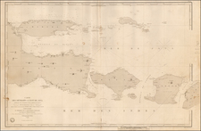
A fine large-scale sea chart of the eastern appraoches to Singapore Harbour, issued in 1931 by the British Admiralty.
This important chart extends from the Central Business District of Singapore, and extends along the East Shore to Tanah Merah. Further south, it embraces the Singpaore Roads, then as now, one of the world's busiest shipping lanes, and the upper reaches of Indonesia's Riau Archipelago (Batam Island is located in the far lower right). On the far left side of the map is the entrance to Keppel Harbour, home to the massive 'Empire Dock', indicative of he fact that Singapore was then the largest base of the Royal Navy in Asia, and along with Hong Kong, Shanghai and Yokahama, one of the leading maritime hubs of Asia.
The chart was viewed as the authoritative navigational pilot for the eastern approaches to the city, and includes unnumberable bathymetric soundings, markings of hazards and magnetic variation. At the time, Singapore recorded 560,000 inhabitants and was one of the fastest growing cities in the British Empire, and the capital of the Straits Settlements, Britain's colonial holdings in the Malay Peninsula. The city center is located in the upper left of the map, and while much land reclamation had already taken place, the urban area was still very much concentrated on the Singapore River. The construction of the Marina District was still far in the future, so that Raffles Place and its Georgian revival buildings occupied a position near the river's mouth, right on the harbour's shoreline.
The present example is exceptional, in that it survives in very fine condition, as most charts of this kind suffered due to heavy use at sea.
The British Admiralty has produced nautical charts since 1795 under the auspices of the United Kingdom Hydrographic Office (HO). Its main task was to provide the Royal Navy with navigational products and service, but since 1821 it has also sold charts to the public.
In 1795, King George III appointed Alexander Dalrymple, a pedantic geographer, to consolidate, catalogue, and improve the Royal Navy’s charts. He produced the first chart as the Hydrographer to the Admiralty in 1802. Dalrymple, known for his sticky personality, served until his death in 1808, when he was succeeded by Captain Thomas Hurd. The HO has been run by naval officers ever since.
Hurd professionalized the office and increased its efficiency. He was succeeded by the Arctic explorer Captain William Parry in 1823. By 1825, the HO was offering over seven hundred charts and views for sale. Under Parry, the HO also began to participate in exploratory expeditions. The first was a joint French-Spanish-British trip to the South Atlantic, a voyage organized in part by the Royal Society of London.
In 1829, Rear-Admiral Sir Francis Beaufort was appointed Hydrographer Royal. Under his management, the HO introduced the wind force scale named for him, as well as began issuing official tide tables (1833). It was under Beaufort that HMS Beagle completed several surveying missions, including its most famous voyage commanded by Captain FitzRoy with Charles Darwin onboard. When Beaufort retired in 1855, the HO had nearly two thousand charts in its catalog.
Later in the nineteenth century, the HO supported the Challenger expedition, which is credited with helping to found the discipline of oceanography. The HO participated in the International Meridian Conference which decided on the Greenwich Meridian as the Prime Meridian. Regulation and standardization of oceanic and navigational measures continued into the twentieth century, with the HO participating at the first International Hydrographic Organization meeting in 1921.
During World War II, the HO chart making facility moved to Taunton, the first purpose-built building it ever inhabited. In 1953, the first purpose-built survey ship went to sea, the HMS Vidal. Today, there is an entire class of survey vessels that make up the Royal Navy’s Hydrographic Squadron. The HO began to computerize their charts in the late 1960s and early 1970s. In 1968, the compilation staff also came to Taunton, and the HO continues to work from there today.
![Asiatic Archipelago [Early Singapore Inset]](https://storage.googleapis.com/raremaps/img/small/66879.jpg)
![[ Lhasa, Tibet ] Bietala](https://storage.googleapis.com/raremaps/img/small/97334.jpg)