


|
||

|

|
|

|
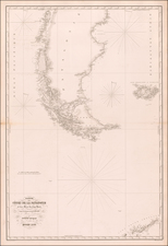
Rare chart of the North Pacific and contiguous parts of the Northwest Coast of America and Northeast Coast of Asia, published by Philippe Buache.
The map illustrates the known Russian Discoveries up to 1750 and attempts to reconcile the information with the model constructed by J.N. De L'Isle, upon his return from serving in Russia in the 1740s. Both the Bay of the West and the channel for a water course via the Archipel de St. Lazare ou Strait of Anian toward Hudson's Bay are shown.
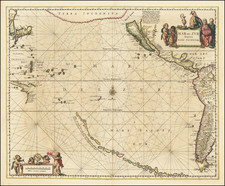
This rare map appeared in Buache's Considerations Geographiques et Physiques sur les Nouvelles Decouvertes au Nord de la Grande Mer . . ., one of the most important works on the Northwest Coast of America pubilshed in the 18th Century. Buache studied under the elder De L'Isle in Paris.Ladd-Mocarski notes:
This work is of the greatest rarity and importance for the history of the discovery and cartography of Alaska and the Northwest coast in general . . . This is the magnum opus of the Delisle-Buache theory of the layout of lands in the North Pacific space.
This work, which was intended to illustrate the Russian discoveries in the Northwest, the Northwest Passage and other contemporary French cartographic conclusions regarding the region, was one of the prime catalysts for the mythical bay of the west. This map illustrates both the Bay of the West, a conjectural route from the Atlantic to the Pacific and the prospect of a River route.
As noted by Everett Graff:
The author, being one of the principal French geographers of his time, was in the unfortunate position of trying to defend the French view of the Cartography of the north Pacific after the earlier conjectures had been pretty thoroughly proven erroneous. His arguments are ingenious in many instances, and his method of ignoring or preverting evidence which does not fit the French theory is fascinating. As soon as the work was issued, it was attacked bitterly from all sides.
An essential map for collectors of the Northwest Coast of America and Bay of the West.
Philippe Buache (1700-1773) was one of the most famous French geographers of the eighteenth century. Buache was married to the daughter of the eminent Guillaume Delisle and worked with his father-in-law, carrying on the business after Guillaume died. Buache gained the title geographe du roi in 1729 and was elected to the Academie des Sciences in the same year. Buache was a pioneering theoretical geographer, especially as regards contour lines and watersheds. He is best known for his works such as Considérations géographiques et physiques sur les découvertes nouvelles dans la grande mer (Paris, 1754).


![Southeastern Portion of California [San Diego, San Bernardino and Inyo Counties]](https://storage.googleapis.com/raremaps/img/small/83750.jpg)