This item has been sold, but you can enter your email address to be notified if another example becomes available.


|
||

|

|
|

|
Stock# 36045
Description
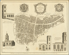
Fine large format plan of London, published in London in 1720.
This map of London, Westminster and Southwark was published in John Strype's 1720 Survey of the Cities of London and Westminster'. The map's title is at top centre in ornamental cartouche, surrounded by cherubs, fruits and mythological figures.
A dedication to Sir George Thorold, Lord Mayor of London, appears at top right, facing the city arms at top left. A compass rose is depicted at the right and a scale of miles at the bottom right.
Reference
Howgego, J. 66.

![[Sea Atlas] Great-Britain's Coasting Pilot: Being a New Exact Survey of the Sea-Coast of England and Scotland From the River of Thames to the Westward and Northward; with the Islands of Scilly, And from Thence to Carlisle; Likewise The Islands of Orkney and Shetland . . .](https://storage.googleapis.com/raremaps/img/small/70378.jpg)
![Carte Reduite des Isles Britanniques Dressee au Depost des Cartes, Plans, et Journaux de la Marine [Reduced Map of the British Isles Drawn at the Depot of Maps, Plans, and Naval Journals]](https://storage.googleapis.com/raremaps/img/small/80011.jpg)