|
||

|

|
|

|
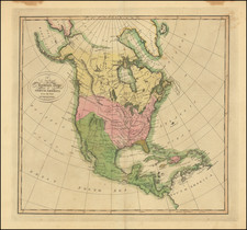
Fine example of De Beaurain's important map of the 13 American Colonies, one of the earliest maps published in Europe to focus on the American Revolution and an important early bit of pro-American French propaganda.
The Chevalier de Beaurain was Royal Geographer to Louis XVI. At the time, France was secretly aiding the colonies, and the map was intended as a propaganda document to prepare the public for the moment when France decided to formally enter the war on the American side. That moment came in early 1778, shortly after the British defeat at Saratoga.
Beaurain used John Mitchell's famous map of 1755 as a base map, and shows all of North America as far west as the Great Plains. But he has modified and updated Mitchell's political boundaries. The Southern English colonies no longer extend indefinitely to the west, but now have their western boundaries at the Mississippi River. The new Canadian province of Quebec, founded in the 1760s, has been added in, and numerous changes and additions have been made in the midwest and deep south. The large and very decorative inset at lower right gives a detailed close-up look at the mid-Atlantic colonies. The title of the inset is Carte de Nouvelle York de la Nouvelle Jersey, d'une Partie de la Nouvelle Angleterre de celle Pensilvany du Maryland et de la Virginy, which is consistent with the second state of the map (see below).
The entire map is heavily embellished, with a rococo title cartouche at upper-left, and a lavish depiction of Mars, the God of War, watching Fame proclaim the new country. The map is one of the most visually impressive of America for the eighteenth century.
The map is very rare. Copies in the United States have been located at the Library of Congress, Newberry Library, Cleveland Public Library, University of Kansas, Yale University, and a unique example in a private collection in Chicago.
The map is known in three states. On the first (Library of Congress), the title of the inset reads: Carte de la Nouvelle York d'une partie de la Nouvelle Angleterre et de la Pensilvany. On the second (this copy), the inset title has been altered to read as above. On the third (known only by a unique copy in a private collection in Chicago), a folding flap has been pasted to the lower margin of the inset, which extends the geography south to Chesapeake Bay.


![Charte von den Vereinigten Staaten von Nord=America mit Luisiana Prag 1818 [Rare Florida inset]](https://storage.googleapis.com/raremaps/img/small/72217.jpg)
![[New England] Tierra Nueva](https://storage.googleapis.com/raremaps/img/small/64626.jpg)