|
||

|

|
|

|
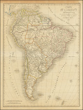
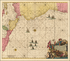
Fine example of Arnold Colom's rare and highly important sea chart of most of South America, first published circa 1656.
Colom's map is one of the earliest obtainable Dutch Sea Charts to show the Sea Coasts of South America and the rarest of the early charts of South America on the market.
The map shows the coastal features of South America south of the Equator, with a large inset of Central America. The chart is executed in the Portolan style, with rhumblines and fine coastal detail for the time period.
Arnold Colom was the son of Jacob Colom, a well regarded Amsterdam bookseller, printer, and chartmaker. Colom produced two sea atlases, a guide and pilot for the Mediterranean and a general sea atlas of the World. Colom's Zee Atlas, published between 1654-58, was one of the largest format sea atlases of the 17th Century, with each chart printed from an oversized copper plate. Koeman describes the atlas as "One of the most important atlases in the well known category of Dutch sea-atlases".
Apart from its rarity, the Zee-Atlas was of importance for its inclusion of the earliest Dutch sea chart of the New Netherlands to appear in an atlas (Jacob Theunisz Lootsman's chart is believed to pre-date it, but seems not to have been regularly published until later), while the "three charts of the oceans are on the same scale (1:14mill.) as Portuguese and Spanish charts of that time. It marked the first time that such charts were published as atlas sheets" (Koeman IV, p.115).