|
||

|

|
|

|
Stock# 35926
Description
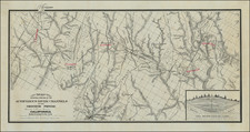
Detailed 4 sheet map of Santa Monica Bay, illustrating a report considering the feasibility of locating a deep water harbor in Santa Monica Bay, conducted by the Army Corps of Engineers in 1890.
The full title of the map is: C hart of Santa Monica Bay California. To Accompany Report of Board of Engineer Officers on Location of a Deep Water Port Between Port Dume and Point San Juan Capistrano . . . 1890.
The finest large format map of Santa Monica Bay published in the 19th Century.
![[ Hand Drawn Map ] Mexico, California, and Texas](https://storage.googleapis.com/raremaps/img/small/99068.jpg)