|
||

|

|
|

|
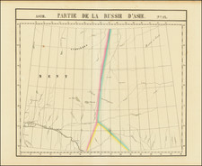
Fine example of Otto Von Kotezebue's important map of the Behring Straits and contiguous regions.
The map illustrates Kotzebue's exploration of the Bering Strait on the ship Rurick in August 1816, one of the most important explorations of the northernmost Pacific after Cook. The map identifies St. Lawrence Island, with only the southeast and western parts definitely known, and the Cape Prince of Wales, Cap Prince de Galles. Cape Krusenstern is also identified.
Kotzebue's expedition was one of the most important Russian expeditions of the 19th Century. Von Kotzebue first accompanied Krusenstern on his voyage of 1803-1806. Following this voyage, Kotzebue given command of an expedition sponsored by Count Nikolay Rumyantsev, in the brig Rurik. In this vessel, with only twenty-seven men, including the naturalists Johann Friedrich von Eschscholtz and Adelbert von Chamisso, and the artist Louis Choris, Kotzebue set out on July 30, 1815 to find a passage across the Arctic Ocean and then to explore the South Pacific.
Proceeding via Cape Horn, he discovered the Romanzov Islands, Rurik Islands and Krusenstern Islands (today Tikehau). From Kamchatka, the expedition proceeded along the northwest coast of North America, discovering Kotzebue Sound or Gulf and Cape Krusenstern in the remote Chukchi Sea.