|
||

|

|
|

|
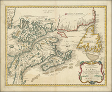
Striking example of De Wit's map of Hudson Bay, Baffin Bay, Button Bay, Davis Straits and continguous parts of the coastline of Canada and Greenland.
The present example is the first state of the map, and is part of a series of charts of the region that began with Van Loon's map of 1668. The basic template remained Hessel Gerritz's printed version of Henry Hudson's charts, published in Amsterdam in 1612. Over time the cartography was improved by Jansson, Blaeu and Sanson, from which the present depiction has been composed. Fredertick De Wit (1630-1706) was by the time this chart was published the leading Dutch mapmaker. His chart came out at a crtiical juncture, for in 1670, the English had founded the Hudson's Bay Company, which would domoniate commerce in the region for the next 250 years. De Wit's map remained the authoritiative printed chart of these subarctic waters for the remainder of the century.
The compostion is traversed with rhumblines and is embellished with two allegorcal cartouches, while a pair of ships fight a battle in the Davis Strait.
De Wit (1629 ca.-1706) was a mapmaker and mapseller who was born in Gouda but who worked and died in Amsterdam. He moved to the city in 1648, where he opened a printing operation under the name of The Three Crabs; later, he changed the name of his shop to The White Chart. From the 1660s onward, he published atlases with a variety of maps; he is best known for these atlases and his Dutch town maps. After Frederik’s death in 1706, his wife Maria ran the shop for four years before selling it. Their son, Franciscus, was a stockfish merchant and had no interest in the map shop. At the auction to liquidate the de Wit stock, most of the plates went to Pieter Mortier, whose firm eventually became Covens & Mortier, one of the biggest cartography houses of the eighteenth century.
![[ Eastern Hemisphere Globe Gores. ] (Nova et integra universi Orbis descriptio)](https://storage.googleapis.com/raremaps/img/small/54480.jpg)
![[ Charting Hall's Quest For The North Pole ] Die Entdeckungen der Amerikanischen Nordpolar-Expedition unter Kapitan C.F. Hall 1871-1873. Reduction der vom Hydrographic Office, U.S. Navy harausgegebenen grossen Karte.](https://storage.googleapis.com/raremaps/img/small/98478.jpg)
![[Arctic Sea] Mari Archipelaghi polari artici Dalla Baia D'Hudson all America Russa](https://storage.googleapis.com/raremaps/img/small/65899.jpg)