


|
||

|

|
|

|
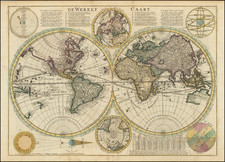
Finely engraved double hemisphere map of the World, originally published by Justus Danckerts circa 1700 and re-issued by Rudolf & Jacob Wetstein and William Smith.
The map depicts California as and Island, the Missississippi River pushed far to the West of its true terminus in the Gulf of Mexico and a massive land bridge (Terra Esonis) extending from California to Japan.
The coastline of Australia is beginning to take shape, although little is known about the southern and eastern coastlines. Van Diemen's Land (Tasmania) is well outlined, as is one coastline of New Zealand, as discovered by Abel Tasman.
Korea is a narrow peninsula, with a massive Philippines dominating the region to the west of China and the Malay Peninsula.
The Northeast Passage is clearly shown, but no polar passage above North America is evident.
The map includes two smaller polar hemispheric projections, along with a model of the Solar System, based upon Ptolemy, an eclipse model, etc.
![Historiarum Indicarum Libri XVI [with:] Indiarum Orientalium Occidentaliumque Descriptio. Pet. Maffei Historiae Harum Verissimae, Dedicata.](https://storage.googleapis.com/raremaps/img/small/102793.jpg)
![(World) Tabu. Nova Orbis [New Map of the World]](https://storage.googleapis.com/raremaps/img/small/102996.jpg)