|
||

|

|
|

|
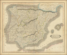
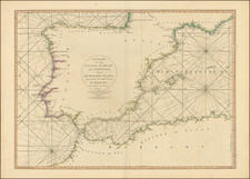
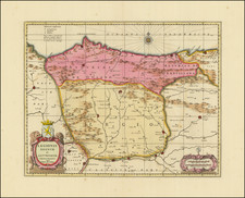
Fine large format sea chart of Biscay Bay and the Southwest Coast of France, extending from Asturias and Galicia to Bretagne.
Bellin's chart is based on extensive surveys and astronomical readings by mariners, and was considered to be the finest available chart of the region during it time. Symbols noted in the title cartouche locate the specific points, usually at headlands, where mariners took observations. The composition is completed by an elegant cartouche, and the seas are traversed by rumblines.
This chart was produced by Jacques-Nicolas Bellin (1703-1772), France's preeminent maritime cartographer and the Premier Ingénieur of the Depot de la Marine (the French Hydrographical Office), as well as the Official Hydrographer of the King Louis XV. The chart was part of Bellin's greatest work, the monumental sea atlas, Hydrographie française (1753).
The present example is an espeically fine example with the additional rhumblines no present on most examples of the map, further evidence of the intended use of the chart for navigation at sea.
Jacques-Nicolas Bellin (1703-1772) was among the most important mapmakers of the eighteenth century. In 1721, at only the age of 18, he was appointed Hydrographer to the French Navy. In August 1741, he became the first Ingénieur de la Marine of the Dépôt des cartes et plans de la Marine (the French Hydrographic Office) and was named Official Hydrographer of the French King.
During his term as Official Hydrographer, the Dépôt was the one of the most active centers for the production of sea charts and maps in Europe. Their output included a folio-format sea atlas of France, the Neptune Francois. He also produced a number of sea atlases of the world, including the Atlas Maritime and the Hydrographie Francaise. These gained fame and distinction all over Europe and were republished throughout the eighteenth and even in the nineteenth century.
Bellin also produced smaller format maps such as the 1764 Petit Atlas Maritime, containing 580 finely-detailed charts. He also contributed a number of maps for the 15-volume Histoire Generale des Voyages of Antoine François Prévost.
Bellin set a very high standard of workmanship and accuracy, cementing France's leading role in European cartography and geography during this period. Many of his maps were copied by other mapmakers across the continent.