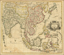
|
||

|

|
|

|
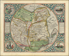
Rare Portugese map of Japan, engraved in 1748 by Miguel Le Bouteux, which appeared in Historia Da Igreja Do Japão . . ., the Portugese translation of Jean Crasset's Histoire de l'Eglise du Japon, originally printed in Paris in 1679, the only edition of Crasset's work to include a map.
Le Bouteux's map divides Japan into its 66 provinces and discusses the successes of the Jesuit Church in conducting over 30,000 baptisms. The map includes a key locating 36 Jesuit Churches in Japan. The sailing ship at the bottom references S. Francisco Xavier, Apostle of Japan (Francisco Xavier, Cosme de Torres (1510-1570), and his arrival at Cangoxima on August 15, 1549.
LeBouteux's map derives from a highly important line of maps which began with Inacio Moreira's now lost manuscript map of Japan, constructed in the 1590s. While the Moreira map is in Portugese, it is derived from an indigenous Japanese style of mapmaking called "gyoki" maps, using cartographic conventions which date to the 9th Century. The style is apparently named for the Buddhist priest who invented the map style, with surviving examples dating back to the 13th Century. Because of this connection, it is believed that Moreira's map derives from maps originally provided to the Jesuits by by Buddhist clergy.
The information contained in the map derives from the rich Jesuit history of studying the geography and political borders of Japan and its 66 daimyo domains. In addition to a rich history of Jesuit relations from the last 16th and early 17th Centuries, a number of manuscript maps were constructed, reflecting the growing knowledge of the Jesuits, supplied by their network of informants.
Perhaps the most significant of the early Jesuit maps was the map of the Portugese mapmaker Inacio Moreira, who was resident in Japan from 1590-98 and was able to compile significant information during his stay. Moreria was born in Lisbon in 1538 and lived for many years in Macao. In 1590, he traveled to Nagasaki with Allesandro Valignano, who was returning from Europe with a Japanese diplomatic contingent who had visited Rome. Moreria surveyed Japan from Kyushu to Kyoto, adding significant local information provided by Japanese informants. He was also able to determine the length of the Japanese ri (distance measurement) and convert it to Spanish and Portugese measurements, allowing him to create the first scientifically accurate map of Japan.
While Moreira's original map is now lost, a description of the map survived in Valignanos' written description of the map which appeared in his Libro primero del principio y progresso de la religion Christiana en Jappon . . . . From this description, modern scholar Jason Hubbard was able to determine that a map engraved in Rome in 1617 by Christophorus Blancus (Rome, 1617) (also lost, but known in a later copy of the map), was in fact a direct copy of Moreira's lost map.
While the Blancus map is now virtually lost, it was copied by several contemporary mapmakers, including the maps made by Jesuity map makers Bernardino Ginnaro and Antonio Cardim and by Engish chart maker Robert Dudley, whose depictions of the map have provided the most widely disseminated and enduring evidence of this fascinating chapter of the cartographic history of Japan.
Crasset's important history of the Jesuits in Japan appeared in a number of editions, but only the Portugese edition included a map. Le Bouteux's map is copied from map the map one included in Antonio Francisco Cardim's Fasciculus e Iapponicis floribus . . . , first published in Rome in 1646. Le Bouteux's map is an enlargement of the original Cardim map, with the text translated from Latin to Portugese.
Miguel le Bouteux (i.e. Jean Baptiste Michel le Bouteux, 1682-1764) came to Portugal under King João V and worked there from 1728 until his death. Very little is known about Le Bouteux, other than the fact that he referred to himself as the Architect of his Majesty.
Le Bouteux's map is very rare on the market, with Hubbard identifying only 3 examples in private collections.
96; Laures 1957: 623; Pagès 1859: 351; Soares: I 136-138.
![[ Japan ] Royaume du Iapon. Designe par le Pere Ph. Briet de la Compagnie de Iesus . . .](https://storage.googleapis.com/raremaps/img/small/75238.jpg)

![[American Lady] [Amerika fujin] | [Chinese Man from Nanjing] [To Daishin Nankin-jin]](https://storage.googleapis.com/raremaps/img/small/55554.jpg)