


|
||

|

|
|

|
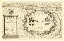
A fine example of the First Edition, First State of Maximilian von Grimm's very rare, monumental plan of Greater Vienna, the first scientific survey of the City.
Maximilian von Grimm's Grundriss der K. K. Haupt und Residenzstadt Wien is one of the most important plans of a European city produced during the Enlightenment era. Vienna was then the capital of one of Europe's great empires and one of the continent's largest cities with over 200,000 inhabitants. Grimm's map is the first accurate general map, or scientific survey, of Vienna and its fast-growing suburbs.
The title of the map translates to "Plan of the Imperial-Royal Capital and Residence of Vienna with its suburbs, showing the new house numbers". The map depicts the old city 'Innere Stadt' within the castellated medieval walls, and the fast-growing suburbs that surrounded the center in all directions. Every street is precisely delineated and labeled, and the outlines of all the built up blocks of the city, along with its grand edifices, are carefully outlined. All of the urban gardens, parks and palace grounds of what was (and still is) one of Europe's grandest cities unfold in their splendor.
While highly valued by contemporary observers, Grimm's map is today widely consulted by historians as the only accurate geographical conception of the Vienna of Amadeus Mozart and other luminaries who inhabited what was a global center of culture. True to the map's title, it details the city's newly established street numbering system, then a critical tool for official and commercial activities, and today an aid to identifying the precise locations of the important historical events which transpired in the city.
While innumerable maps and views of Vienna had been published since the inclusion of the first view of city in the Nuremburg Chronicles (1493), up to the end of the 18th-century no scientific survey of the City and its environs had been undertaken. This was not because of a shortage of skilled surveyors and advanced scientific equipment in the city. Indeed, the Austrian military engineers were amongst the finest surveyors in Europe. Rather the imperial army strongly discouraged the publication of detailed surveys of cities, out of fear that it might fall into enemy hands. The army was so concerned that they even discouraged the actual act of surveying cities in and of itself, lest it result in some illicit map. While the authorities in many European capitals had already permitted, and in some cases funded, scientific surveys of their capitals, placed in the heart of Europe, in the path of numerous foreign armies, the Austrians had no such luxury.
The leading cities of the Austrian Empire, such as Vienna, Prague, Brussels and Antwerp (Belgium was then the Austrian Netherlands) were vibrant commercial and cultural centers. Civilian administrators and commercial interests urgently needed accurate general maps of cities to effectively carry out their mandates. Since the end of the Seven Years' War in 1763, tension over the question of permitting urban surveys developed between military and civilian stakeholders. Gradually, urban surveys of various kinds were permitted by the military, whose active cooperation was often a prerequisite to completion of such surveys.
A major breakthrough came in 1769, when Josef Daniel Hüber created a monumental building-by-building panoptic view of Vienna. Published in 1777, it ranks as one of the finest accomplishments of urban mapping and topographical artistry of the 18th-century. Importantly, however, Hüber's work only depicted central Vienna immediately around and within the city's walls, a view of limited military utility.
Critically, the regional government the Austrian Netherlands proved to be much more lenient on the mapping question than the authorities in metropolitan Austria. Indeed, from 1771 to 1778, all of modern Belgium was scientifically mapped by Joseph-Jean-François, Comte de Ferraris, resulting in the publication of the Carte Marchande. Permitting the even more detailed mapping of cites and their immediate surroundings was seen the natural next step.
Shortly thereafter, Maximilian von Grimm received the support of the local authorities to conduct the first scientific survey of Antwerp. This was published as the Plan der Stadt Antwerpen an der Schelde in oestreichischen Niederlanden (Augsburg, 1785).
The highly quality and practical utility of this map won Grimm a great deal of notice and acclaim throughout the Austrian Empire. Civilian stakeholders in Vienna were highly desirous of having a similar plan made of the imperial capital and its burgeoning suburbs, however, resistance continued from military circles.
Ironically, it was military considerations that eventually led to the undertaking of the first scientific survey of Greater Vienna. Historically, during times of military emergency, the Austrian army had a difficult time rounding up conscripts in the myriad streets of Vienna. Houses were not numbered and the old signs, such as 'under the Golden Rooster', that had traditionally identified residences and shops were increasingly hard to sight, or were taken down altogether. To help army 'press gangs' locate specific residences, on Christmas Eve 1770, Empress Maria Theresa instituted the policy of the "general conscription of souls and houses" ordering all of the capital's residences to "make the numbers on all houses legible and visible, on punishment of 9fls. [Silver Florins]".
From 1771 onwards, the city's streets were gradually numbered, however, this process was poorly coordinated and the haphazard numbering proved to be confusing. The situation was not helped by the fact that the citizenry generally resented the measure, so did little to help rationalize the process.
In the early 1790s, it was decided that all of Vienna's streets would be completely renumbered, but following a systematic plan overseen by central authority. As war with France was imminent, the Austrian army was only too happy to support any measures that would aid its conscription efforts. Public cooperation was garnered with the promise from the authorities that the renumbering would help to combat crime such "that dissolute and dangerous people" could be more easily tracked down.
It was in this context that Maximilian von Grimm was authorized to conduct the first scientific survey of Vienna and its suburbs. Grimm was blessed by the fact that, for taxation purposes, Vienna had recently commissioned a comprehensive series of cadastral surveys that provided accurate outlines of the city's individual blocks. Grimm incorporated these plans, along with his own extensive surveys, into a grid regulated by trigonometric measurements to create the first truly accurate map of Greater Vienna. The new street numbers were then applied to each and every inner-city and suburban block.
Grimm's manuscript was completed in 1796, and was engraved by Hieronimus Benedicti, and published by the leading Vienna map publishing firm of Artaria.
The importance of Grimm's map was enduring, as it formed the basis for all maps of the city and its environs for some decades. It also proved to be an inspiration for subsequent scientific surveys of cities in the Habsburg Empire, such as Joseph Jüttner's map of Prague, Grundriss der Königlichen Hauptstadt Prag (1820).
The present first edition, first state of Grimm's map of Greater Vienna is very rare. Its rarity can perhaps be accounted for by the fact that, owing to its great size and expense, few copies were originally published, and then the vast majority of this issue perished due to use. We are aware of only one other example appearing in dealers' catalogs during the last 25 years, and are aware of no examples appearing at auction over the same period.
![[ Transylvania ] Karte von Siebenberg nach den besten Hulfsmitteln verfast](https://storage.googleapis.com/raremaps/img/small/103015.jpg)

![[ Vienna ] Viennense Territorium ob res Bellicas Inter Christianos et Turcas Nuperrime Editum](https://storage.googleapis.com/raremaps/img/small/80253.jpg)