|
||

|

|
|

|
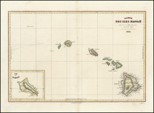
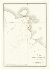
Rare early view of Honolulu Harbor and environs, extending from the Old Harbor to Diamond Head, which accompanied Abel Aubert DuPetit-Thouars monumental work on the Pacific.
This is one of the earliest obtainable views of Honolulu, published prior to the re-establishment of Honolulu as the Capital of Hawaii in 1845. The view is very rarely offered for sale, as the complete Du-Petit Thouars is rare and highly coveted by collectors.
Honolulu Harbor was long prized by the native peoples of Oahu, although it was largely overlooked by the first wave of European explorers. The harbor was first "discovered" in 1794, by Captain William Brown of the Butterworth. In 1804, Oahu was conquered by King Kamehameha the Great, and included as part of the united Hawaiian Kingdom. The national capital was promptly moved to Waikiki, and then Honolulu Harbor in 1809, before it was returned to Kona, on the Island of Hawaii, in 1812.
The first known mapping of Honolulu Harbor was conducted by the Russian explorer Otto von Kotzebue in 1816-7, whose pair of charts of the area were published in St. Petersburg in 1823. This was followed by a manuscript chart of the harbor drawn by 'Tabulevich', the draftsman for the voyage of Vasili Golovnin, in 1818 and Louis Isadore Duperry's Plan du Port D'Onorourou (Paris, 1819). During this period, Honolulu was a low-density and spread-out village, traversed by rough paths, with no formal plan or streets.
During the 1820s and 1830s, Honolulu increasingly became a key port for Trans-Pacific trade and the whaling industry. The south coast of Oahu had the finest anchorages and the largest expanse of prime agricultural land in Hawaiian Islands. Seeking to bring order to the chaotic settlement, in 1838, Queen Kahumanu II decreed that a fixed series of streets should be constructed across the town.
By the mid-1840s, Honolulu had emerged as the premier town of the Hawaiian Islands, surpassing Lahaina in both population and commercial importance. The national capital was moved back to Honolulu in 1845. That year, Governor Kekuanaoa of Oahu, commissioned the German surveyor H. Ehrenberger to create the first formal street survey of Honolulu, which was published in The Friend on October 1, 1845. This was soon followed, in 1847, by Theophylus Metcalf's manuscript street plan of Honolulu.
DuPetit-Thouars' 11 volume Voyage Autour du Monde sur la Frégate la Vénus pendant les années 1836-1839, publié par ordre du Roi, sous les auspices du Ministre de la Marine, par M. Abel du Petit-Thouars, Capitaine de vaisseau, Commandeur de la Légion d'honneur . . . published in Paris (1840-1844, 1855 and 1864) provides a remarkable and comprehensive look at the Pacific, including Hawaii, as well as California.
During the 1830s, the French interest in scientific exploration and commercial reconnaissance of the newly independent nations in the Americas was at its peak. Dupetit-Thouars visited Valparaiso, Callao, and Honolulu, and reached Kamchatka in August 1837. He then recrossed the north Pacific to the California coast, visiting Monterey, San Blas, and Acapulco, and finally the Galapagos in January 1838. After spending 6 months in the Galapagos, the entourage left for the South Pacific, before returning to France in June 1839.