
This item has been sold, but you can enter your email address to be notified if another example becomes available.


|
||

|

|
|

|
Stock# 35562
Description
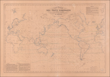
Rare separately issued map of the World, promoting the shipping lines of the Canadian Pacific Railway and Steamship Lines.
The map illustrates in red the various shipping lines and distances and transit times for various ports of call in New Zealand, Australia, Southeast Asia, China, Japan, Hawaii, the Philippines, Argentina, South Africa and Europe, including service via the Suez Canal and Panama Canal.
Includes two decorative vignettes.
We note only the copy in the Huntington Library, Canadian National Archives and Nationl Library of New Zealand.
Condition Description
Minor soiling.
![[ World Powers - Confrontation or Relaxation? ] Weltmachte-Konfrontation oder Entspannung?](https://storage.googleapis.com/raremaps/img/small/90939.jpg)
![(World - First State!) Benedict Arias Montanus Sacrae Geographiae Tabulam ex Antiquissimorum Cultor. [Pre-Dutch Discovery Depiction of Australia]](https://storage.googleapis.com/raremaps/img/small/93232.jpg)
