


|
||

|

|
|

|
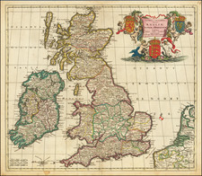
Striking plan of London and environs, which was first published by Johannes De Ram in Amsterdam.
The map includes a 10 point key in the top left corner bearing the names of Southwark landmarks, and a 148 point key in the top-right bearing the names of locations on the other side of the Thames. The smaller title contained in a classical cartouche surmounted by the arms of London with dragon supporters.
Originally Joannes de Ram's map celebrated William and Mary's ascent to the English throne after the Glorious Revolution, giving the country a Dutch monarch. For this state the original portraits have have been replaced with a view of Westwood Park, Worcestershire and appeared in Vander Aa's La Galerie Agréable du Monde: Grande Bretagne et L'Irlande."
Pieter van der Aa (1659-1733) was a Dutch mapmaker and publisher who printed pirated editions of foreign bestsellers and illustrated books, but is best known for his voluminous output of maps and atlases. Van der Aa was born to a German stonecutter from Holstein. Interestingly, all three van der Aa sons came to be involved in the printing business. Hildebrand was a copper engraver and Boudewyn was a printer.
![Carte Reduite des Isles Britanniques Dressee au Depost des Cartes, Plans, et Journaux de la Marine [Reduced Map of the British Isles Drawn at the Depot of Maps, Plans, and Naval Journals]](https://storage.googleapis.com/raremaps/img/small/80011.jpg)

![[Sea Atlas] Great-Britain's Coasting Pilot: Being a New Exact Survey of the Sea-Coast of England and Scotland From the River of Thames to the Westward and Northward; with the Islands of Scilly, And from Thence to Carlisle; Likewise The Islands of Orkney and Shetland . . .](https://storage.googleapis.com/raremaps/img/small/70378.jpg)