|
||

|

|
|

|
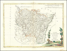
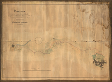
An attractive early 18th-century map of the Duchy of Savoy by Petrus Shenck, after an original map by Nicolas Sanson.
This fine map embraces the Duchy of Savoy at the height of its military and cultural influence. Savoy existed as an independent state from 1416 to 1860, and consisted of the modern Italian states of Piemonte and Valle d'Aosta, as well as the French regions of Savoie and Alpes -Maritimes (including Nice). The maps extends from the Gulf of Genoa up as far north as Lake Geneva. The Duchy of Savoy's capital was Turin, which at the time that the map was made was one of Europe's great centers of Baroque art and architecture. The country was bilingual, owing to its large French and Italian populations. Savoy was also at the center of military affairs in Europe, as its warrior prince, Eugene of Savoy (1663-1736), was one of the continent's most brilliant and successful generals.
The map was originally creared by Nicolas Sanson, the cartographer to King Louis XIV of France, and was subsequently reissued by the Amsterdam publisher Petrus Schenk.
Peter Schenk the Elder (1660-1711) moved to Amsterdam in 1675 and began to learn the art of mezzotint. In 1694 he bought some of the copperplate stock of the mapmaker Johannes Janssonius, which allowed him to specialize in the engraving and printing of maps and prints. He split his time between his Amsterdam shop and Leipzig and also sold a considerable volume of materials to London.
Peter Schenk the Elder had three sons. Peter the Younger carried on his father’s business in Leipzig while the other two, Leonard and Jan, worked in Amsterdam. Leonard engraved several maps and also carried on his father’s relationship with engraving plates for the Amsterdam edition of the Histoire de l'Académie Royale des Sciences.
Nicholas Sanson (1600-1667) is considered the father of French cartography in its golden age from the mid-seventeenth century to the mid-eighteenth. Over the course of his career he produced over 300 maps; they are known for their clean style and extensive research. Sanson was largely responsible for beginning the shift of cartographic production and excellence from Amsterdam to Paris in the later-seventeenth century.
Sanson was born in Abbeville in Picardy. He made his first map at age twenty, a wall map of ancient Gaul. Upon moving to Paris, he gained the attention of Cardinal Richelieu, who made an introduction of Sanson to King Louis XIII. This led to Sanson's tutoring of the king and the granting of the title ingenieur-geographe du roi.
His success can be chalked up to his geographic and research skills, but also to his partnership with Pierre Mariette. Early in his career, Sanson worked primarily with the publisher Melchior Tavernier. Mariette purchased Tavernier’s business in 1644. Sanson worked with Mariette until 1657, when the latter died. Mariette’s son, also Pierre, helped to publish the Cartes générales de toutes les parties du monde (1658), Sanson' atlas and the first French world atlas.
![(Franco-Prussian War) Fameux Probleme Algebrique & Politique [Famous Algebraic & Political Problem]](https://storage.googleapis.com/raremaps/img/small/86125.jpg)