This item has been sold, but you can enter your email address to be notified if another example becomes available.


|
||

|

|
|

|
Stock# 35329
Description
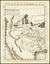
Important early map of Minnesota Territory, including all of Dakota, from the rare Cowperthwait Desilver & Butler editon of Mitchell's Universal Atlas.
The map is based largely on the works of Nicollet and Pope, and includes extensive notes on early exploration and topography throughout. An essential map for Minnesota and Dakota collectors. One of the earliest editions of the map, first issued in 1850, the year after Minnesota became a territory.
Massive Pembina and Dacotah counties in the west, with many Indian Tribes, forts and toerh early exploration notes shown.
An essential map for Minnesota and Dakota collectors.
Condition Description
Narrow upper left margin