|
||

|

|
|

|
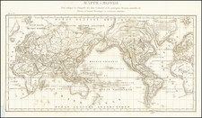
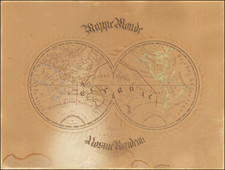
The rare first edition of Le Rouge's map of the world, preceeding the second edition of 1748, which was long believed to be the first appearance of the Russian discoveries of Tchirkow and Behring along the NW Coast of America. This edition notes the various Russian explorations in 1741, 1742 and 1743. The Riviere Longue first propogated by Lahontan is very much in evidence, but there is virtually no sign of a coastline north of Cape Mendocino. In the later edition, the map was substantially revised and the classic conjectural cartography in this region was shown, based upon the reports of the Russian discoverers in the region through 1747, and a number of large and mythical land masses and waterways added, although the date on the map was left unchanged. The map also includes a single New Zealand Coastline, and unknown east coast of Australia,with Van Dieman's Land and New Guinea still attached to the continent. Dampier's passag is noted, with a curious representation of New Brittania. The mytical Compagnie Land still appears north of Japan. The map imagery is a large and resplendent celebration of the Age of Science. The twin map hemispheres are dominated by scenes depicting scientific instruments within Baroque landscapes. The map has been restored at the left and right sides, including some facsimile work, primarily in the margins and outside of the map portion of the image. In all, a visually striking example.