|
||

|

|
|

|
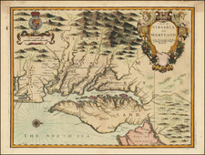
Important early English Chart of the Chesapeake and Delaware Bay region, based upon the seminal work of Augustine Hermann.
The map was originally issued by John Thornton and William Fisher in 1689, with revisions over the course of the next 100 years. Thornton & Fisher's two sheet map of the Chesapeake is based upon Augustine Hermann's highly influential map of the region. Originally issued in 1689 for inclusion in the English Pilot, Fourth Book, the map went through 5 states between 1689 and 1728 and was later reissued by Grierson in 1730 Mount & Page (1742 and after). The map derives from Thornton's rare map of the same region issued first with Robert Greene in 1675 and later with Robert Morden and Philip Lea. The map incorporates information form Thomas Holme's rare map of Pennsylvania issued in 1687, for which Thornton was the distributor.
The present example is the 5th of 5 states of the plate, lacking the Thornton & Fisher imprint and with addition of a sandbar off Cape Charles and numerous soundings along the Atlantic coast. This 5th state appeared 1728-1742.

![[ Pictish Warrior Woman ] Feminae Pictae icon V](https://storage.googleapis.com/raremaps/img/small/99648.jpg)