|
||

|

|
|

|
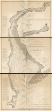
Important early American map, depicting the prospective road and canal routes linking the Delaware and Chesapeake Bays.
The focal point of the map is transportation in the Mid-Atlantic Colonies. Solid lines indicate three proposed canal routes between tributaries of Chesapeake Bay and the Delaware River, and three proposed roads are shown by double dotted lines.
The map was originally engraved by Smithers and published by the American Philosophical Society in 1771, to accompany An Abstract of sundry papers and proposals for improving the inland navigation of Pennsylvania and Maryland…, which appeared in the first volume of the Transactions of The American Philosophical Society (APS). Formed in Philadelphia in 1769, the mission of the APS was "the promoting of useful Knowledge in general, and such branches thereof in particular, as may be more immediately serviceable to the British Colonies." It met regularly to hear papers submitted by its members and others and in 1771 published the first volume of its Transactions. The second edition of the volume, from which this example of the map was taken, appeared in 1789.
Per Wheat and Brun the map is in its third state, with "Turkey Pt." and "Pursusey Isl" added. The unusual device at left is a "machine for cutting files," placed here to illustrate to illustrate another article in the Transactions.
The proposal for new roads and canals linking the back country to the Philadelphia area developed out of competition between that city and Baltimore for the commerce of the frontier:
To avoid the high costs of land transportation over an inadequate road system, farmers in central Maryland and Pennsylvania shipped produce to Baltimore by way of the Susquehanna River, which empties into Chesapeake Bay. Thus, Baltimore had grown dramatically as a major port by the 1750s and 1760s.
Philadelphia merchants believed that much of the profit from trade passing through Baltimore rightfully belonged to them since significant amounts of that city's commerce, primarily its trade in grain, originated in western Pennsylvania. In an effort to recoup the revenue lost to Baltimore, Thomas Gilpin, a prosperous Quaker merchant, began to study the feasibility of constructing a canal to link the Chesapeake with Delaware Bay, thereby providing an efficient route from western Pennsylvania and Maryland to Philadelphia via the Susquehanna.
(Pritchard and Taliaferro, Degrees of Latitude, p. 232)
Based in Philadelphia as it was, the sympathies of the APS were with the area's merchants. At the prompting of Gilpin, in early 1769 it assembled a team to survey potential canal and road routes. In all the team examined five possible canal routes, all on the Delmarva Peninsula, as well as three potential roads between the Susquehanna and Schuylkill Rivers. The results of those surveys were summarized in the "An abstract of sundry papers and proposals," from which this map was removed. The team enthusiastically recommended the immediate opening of a new road from Peach Bottom on the Susquehanna to Christiana Creek, where goods could then be shipped by water to and from Philadelphia. It also offered tentative support for any one of three possible canal routes between the Elk River, a tributary of the Chesapeake, and the upper reaches of the Delaware.
Nothing came of these proposals at the time, as economic development was put on hold by the events of the American Revolution. In 1804 construction finally began on a canal from the Elk River to the Christina River in Delaware, but was put on hold in 1806 for lack of funds. The project resumed in the 1820s, and the Chesapeake and Delaware Canal finally opened in 1829.
Description excerpted from Boston Rare Maps: www.bostonraremaps.com/catalogues/BRM1345.HTM
![A New and Exact Map of the Dominions of the King of Great Britain on ye Continent of North America . . . [Beaver map]](https://storage.googleapis.com/raremaps/img/small/101277.jpg)