


|
||

|

|
|

|
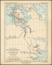
A rare large scale promotional map of the Canadian Prairies issued by the Hudson's Bay Company to encourage migrants to settle in the region.
This finely detailed map embraces most of the Canadian Prairies, including all of the southern portions of modern Manitoba, Saskatchewan and Alberta. It was issued by the Hudson's Bay Company as a promotional piece to encourage migration to and settlement in the region, which had recently been made accessible by the construction of the Canadian Pacific Railway (CPR). The map shows the land divided into mile-square townships running north from the U.S. border (the 49th-parellel) up the North Saskatchewan River.
The map shows the route of the CPR, which had just been completed as far west as the Rocky Mountains. The commerce of the Prairies was then commanded by the city of Winnipeg, Manitoba, then one of the great boomtowns of North America. The townships colored in pink, which make up southern Manitoba and hug the main CPR line, indicate lands that had already been sold to migrants or otherwise reserved by the railway (a major land owner). The innumerable townships colored in yellow indicate lands that are were still available for sale to the target audience of this map.
In 1869, the Hudson's Bay Company (HBC) relinquished to Canada its title to Rupert's Land, the vast territory of the watershed of Hudson Bay to which it had held royal title since 1670. In return the HBC retained certain privileges, including ownership of some of the lands that were to be developed. In order to settle the Prairies, vast amounts of capital would need to be spent in order to build railways, endeavors that were far beyond the remit of the HBC. In 1870, the province of Manitoba was created, while the rest of the region became the vast Northwest Territory.
In 1871, the Dominion Land Surveyors (DLS) began to survey and assess the agricultural and natural resource values of the lands, dividing it into a neat grid of square-mile townships in the American fashion. Lands in southern Manitoba and near the CPR line, which was rapidly built across the Prairies from 1880, were placed on the market and quickly bought up in the land boom of 1882-3. However, the vast 'fertile belt' that formed a giant crescent trough the northern Prairies remained to be settled.
In 1879, the HBC, which owned section 8 and three-quarters of section 26 of each township (accounting for 5% of the land), turned its attention to developing the fertile belt. That year the HBC land commissioner, Charles John Brydges (1827-89), charged his chief surveyor Montague Aldous to survey the remaining townships up to the south bank of the North Saskatchewan River and to conduct a detailed assessment of the economic potential of each quadrant. In 1881, Brydges issued a map that showed the preliminary results of Aldous' surveys, and was the precursor to the present work. Once the surveying project was complete, he issued the present promotional map in an effort to sustain the land boom of 1882-3. The map not only gives a precise geographical perspective of the lands available, it also includes a lengthy essay extolling the virtues of the Prairies to prospective migrants.
Unfortunately, in 1884, the economic bubble created by the land boom burst, causing land values to collapse. For some years it became very difficult to attract new settlers to the Prairies, and major landowners such as the CPR and the HBC placed many of their marketing endeavors on hold. For this reason, it seems that very few examples of the present map were ever issued.
The present map is exceedingly rare and seemingly unrecorded. We are not able to find any references to the map in dealers' catalogs or in institutional holdings.

![[An English Propaganda Map In French] Carte Des Possessions Angloises & Francoises Du Continent De L'Amerique Septentrionale 1755.](https://storage.googleapis.com/raremaps/img/small/86975.jpg)