


|
||

|

|
|

|
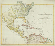
Fascinating and very scarce map, showing the US immediately after the Louisiana Purchase, which is very clearly delineated as Lousiana [sic].
A large region in the Midwest is labeled Tennessee et Kentuck, although the region extends considerably west of to reach the Mississippi River, the only time we have ever seen these two states reaching the Mississippi in this fashion. Large unnnamed Mississippi Territory, shown just after its creation. The Grosse Meadows Nation is shown on the Missouri River, not far from Alt Ft. St. Louise. Fort Natchitoches is clearly named, as is Presidio dello Adiais. Nice detail along the Rio Grande. Many Indian Tribes shown in the west. A rare foreign look at the Mississippi Valley and contiguous regions shortly after the Louisiana Purchase.
![[ Atlas - Florida and Southern Canal Projects ] Travaux d'améliorations intérieurs projetés ou exécutés par le gouvernement général des États-Unis d'Amérique, de 1824 à 1831 [complete with:] Travaux d'améliorations intérieurs projetés ou exécutés... Atlas.](https://storage.googleapis.com/raremaps/img/small/85067.jpg)
![Carte De La Louisiane Et Du Cours Du Mississipi . . . Juin 1718 [1st State!]](https://storage.googleapis.com/raremaps/img/small/59797.jpg)