


|
||

|

|
|

|
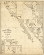
A historically significant and exceedingly rare early map of San Francisco and the northern Peninsula, augmented with important contemporary manuscript additions that make it one of the first maps to delimit the modern boundaries of San Francisco and to show its surveyed boundary with San Mateo County.
The Map of the Northern Portion of San Francisco County is one of the rarest of the great early maps of San Francisco and environs, and the present example has been rendered into a significant historical artifact owing to its contemporary manuscript additions.
In 1852, the City of San Francisco occupied only the northeastern portion of the current city and county of the same name. The city was also part of the County of San Francisco, which was separately governed and included the area occupied by today's San Francisco as well as most of modern San Mateo County. However, San Francisco's Board of Supervisors harbored ambitions to expand the city beyond its modest limits. As the mapping of the city had hitherto generally been tightly confined to the densely settled area in what is now downtown San Francisco, they decided to commission a map that showed the territory which ran west and south of the city.
Overall responsibility for the map fell to Clement C. Humphreys, the Surveyor of the County of San Francisco. Humphreys compiled the very best available surveys and tendered them to Alexander Zakreski, a master cartographer and draughtsman, whose biography is one of the most fascinating of all early San Franciscans.
Alexander Zakreski (1799-1866), born Aleksander Zakrzewski, was a brilliant Polish military engineer and revolutionary who had to flee his native land owing to his opposition to Russian rule. He then settled in France where he lithographed a map of Paris in 1839. He was subsequently caught up in the Revolution of 1848 and had to leave the county, finally arriving in San Francisco in 1850. Zakreski soon found work as a mapmaker and lithographer, working with various governmental agencies, as well as commercial publishers. In 1852, he worked closely with the County Surveyor's Office. He is perhaps best known for bing the author of The only correct & fully complete Map of San Francisco (1854).
Once the manuscript draft of the map had been completed, the Board of Supervisors issued their Joint Resolution no.282, dated December 24, 1852:
"Authorizing the Reviser of the City Ordinances, etc., to have a map lithographed…The Said map being a map of the northern portion of San Francisco County, Compiled in the county Surveyor's Office, June 1, 1852, by Clement C. Humphreys, County Surveyor, and copied by Alexander Zaresky [sic]."
The map was printed map the firm of B.F. Butler, and included within a book issued by the Supervisors, detailing the city's laws and regulations, the Manual of the Corporation of the City of San Francisco (dated 1852, but issued 1853), which is today virtually unobtainable.
The map as issued (before the addition of the manuscript survey lines and annotations) embraces all of the San Francisco Peninsula from San Bruno northwards. It labels all of the ranchos (including their acreages), major regional roads, as well as the Presidio and the Telegraph Station above Fort Point. The vast barren area to the southwest of the Golden Gate is labeled the 'Great Sand Bank'. While the city limits of San Francisco are demarcated (including the boundary extensions of 1850 and 1851), the only man-made detail within the city itself is the 'Line of Market Street' and the 'Mission' (Mission Dolores), owing to the fact that this was primarily intended to be a regional map. Relief is expressed through finely engraved hachures and marshlands are carefully distinguished.
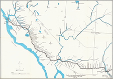
The manuscript additions to this example of the map are of great historical significance and, due to their content and scientific precision, were clearly rendered by an official surveyor working under the aegis of the City & County of San Francisco. There are neat red manuscript grid of lines that covers only what is today the City & County of San Francisco, while what is now northern San Mateo County is left free of manuscript additions, save for the name 'San Mateo County'. This indicates that the manuscript additions were added to the printed map sometime in or just before 1856.
For complicated political reasons, it was decided to divide San Francisco County into two parts, along the southernmost line of the manuscript grid, which ran from Lake Merced across the Peninsula to a point just north of San Bruno. On April 19, 1856, the northern areas became the modern City & County of San Francisco (still the only combined city-county in California), while the southern areas became San Mateo County. This map is therefore one of the earliest to show the boundaries of San Francisco in its modern form and possibly the earliest map to reference San Mateo County and its boundary line with San Francisco. Indeed, the title of the map has been altered in pencil to read Map of the Northern Portion of San Mateo County and the Entire of San Francisco County Sectionized & Compiled from Surveys.
The 'sectionalized' manuscript grid was imposed upon the map by the San Francisco surveyors in order to accord with the U.S. General Land Office's (GLO's) Public Land Surveying System (PLSS), which since the 1780s had sought to systematically survey the American West into a precise grids of 1 square mile townships. The numbering of each township on the grid is staggered to account for the different surveying quadrants into which they fall. The grid was regulated by control lines in relation the great base line which ran though Mount Diablo, in the East Bay, which since1851, had been the base point for the PLSS throughout Northern California and Nevada. The neat manuscript notes in red along a couple of the key control lines are geodetic coordinates employed by the surveyors to ensure that the grid imposed in San Francisco precisely relates to the rest of the survey system. The imposition of the PLSS in San Francisco was considered to be 'best practice' in surveying, although the city's varied topography ensured that the grid seldom shaped man-made features on the ground, such as the placement of roads and cadastral boundaries (as was the case in the Great Plains, for example).
In addition, the surveyors distinguished, in manuscript color, a few areas of key interest to the city's future development. Most prominent is the great ovoid form of Rancho San Miguel (outlined in dark green). In 1845, the Mexican government had granted the 4,443-acre rancho to José de Jesús Noé, who served on two occasions the alcalde of San Francisco. The area encompassed the modern neighborhoods of Noe Valley, the Castro, Glen Park, Diamond Heights, and St. Francis Wood.
Following the American conquest of California and, as required by the Land Act of 1851, Noé's title to the rancho was upheld by the Public Land Commission. By 1856, Noé had for some years been steadily selling off parts of the rancho to private developers. While much of the land would be developed over the coming decades, much of the rancho would be caught up in litigation involving claims of Noé's heirs, issues that would not be resolved until 1895.
To the northeast of the rancho, the Mission District is colored in light green. This area was then a primary focus of the Board of Supervisors who wished to channel dense urban development into the area, one of the only remaining areas of flat land in the entire city. Likewise, 'Nuevo Potrero' (Potrero Hill), colored in orange, with its location along the Bay shore near downtown, it was seen as an ideal place for land reclamation projects and the development of industrial infrastructure.
Other notable manuscript additions include the location of 'Lone Mountain Cemetery', the great necropolis located in today's Laurel Hill neighborhood (since removed); an annotation marking 'the Western Addition', noting the new areas added to the city beyond Nob Hill in 1850 and 1851; and 'Horner's Addition', a part of the Rancho San Miguel that that had been purchased by John Meirs Horner in 1853, and was slated for development.
The Map of the Northern Portion of San Francisco County is one of the great rarities amongst important early works of San Francisciana. We are aware of it appearing only once at auction in the last 25 years and are not aware of it appearing in any dealer's catalogs over the same period. Moreover, the last recorded sale of the Manual of the Corporation of the City of San Francisco, complete with its 2 maps, occurred in 1979 (Warren Howell). Moreover, the extensive and important manuscript additions to the present example elevate it to the level of a unique and important artifact detailing the early development of San Francisco and San Mateo County.
![(San Diego -- WWI Panoramic Photograph) Camp Kearny. Co. M. 158th Infantry [World War I panoramic group portrait of U.S. Army Infantryman at Camp Kearny, San Diego]](https://storage.googleapis.com/raremaps/img/small/91707.jpg)