|
||

|

|
|

|
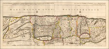
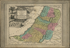
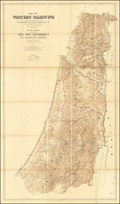
The rare 'Old & New Testament Edition' of Claude Conder, Charles Wilson and Horatio Kitchener's map, Palestine from the Surveys conducted for the Committee of the Palestine Exploration Fund, published by Stanford's Geographical Establishment.
This finely executed map represented the culmination of almost two decades of scientific surveying in what is now Israel, Jordan and Lebanon conducted by the Palestine Exploration Fund. Combining their surveys of Western Palestine (Israel and Lebanon) and Eastern Palestine (Jordan) for the first time, the Fund published a map of all of Palestine, which was issued in two distinct formats, one being a 'Modern Edition' and an 'Old & New Testament Edition,' which is the example we offer here. The Modern Edition was an empirical military topographical map, while the Old & New Testament edition featured all of the details present on the former, but augmented with extensive historical information. Issued in 12 sheets, it features a large scale of 3/8 of an inch to 1 mile, enlivened with fine chromolithographic color.
The map is the first scientific topographical map to embrace all of Palestine on both sides of the Jordan River, with the present 'Old & New Testament edition' featuring extensive information on the ancient history of Israel. One will immediately notice that traditional territories of the Twelve Tribes of Ancient Israel; Reuben, Simeon, Levi, Judah, Dan, Naphtali, Gad, Asher, Issachar, Zebulun, Joseph and Benjamin, which are distinguished on the map in brilliant color. All major features of the landscape are depicted in exacting detail, including rivers, wadis, the Dead Sea, the Sea of Galilee, while the hills and mountains are expressed in finely shaded relief. All of the modern settlements are labeled, however, a fascinating feature of the map is that it also includes the ancient names of villages and other historically important locations. Employing color-coding and different fonts, the map features the different place names as they relate to the Old Testament, New Testament, Apocrypha (storied/unconfirmed names), Josephus (as contained in the writings of Flavius Josephus, 37-100 AD, the great Alexandrine Jewish chronicler), and the Talmud.
The story behind the creation of the map is most fascinating. In 1872, Claude R. Conder was selected by the Palestine Exploration Fund to head a scientific survey of Western Palestine (central and northern Israel and southern Lebanon). An ambitious endeavor, it aimed to map all of this mountainous region to advanced trigonometric standards, with maps to be published at a large scale of 1 mile to 1 inch, the precise same criteria as employed by the Ordnance Survey of England.
Conder was assisted by the young Lt. Horatio Kitchener who would later go on to fame as head of the British Army. Work began in July 1872, and while the party endured difficult and dangerous conditions, it persevered in ensuring that the quality of their surveys met with the highest standards. In 1875, Conder was wounded following an attack by brigands near Safed and had to return to England, leaving the project to be finished by Kitchener. Their fine map, which embraced over 6,000 square miles of surveys, was published as a Map of Western Palestine (1878), and was issued in 26 sheets. The map was followed by an eight-volume series of text (1881-5), detailing the region's topography and toponomy, as well as the local flora and fauna.
In 1881 Conder returned to the field, with the objective of mapping Eastern Palestine (Jordan). His party included the skilled military surveyors A. M. Mantell, T. Black and G. Armstrong, and succeeded in mapping around 500 square miles of territory between the Dead Sea and Amman. However, Conder had to suddenly cease the survey when members of his team were called for military service elsewhere. Their map, Survey of Eastern Palestine was published at some point in the 1880s, although the precise dating of this map is still a subject of debate. The Memoir of the expedition was published in 1889.
As a culmination of the Fund's mapping programs, in 1890 it published the Palestine from the Surveys conducted for the Committee of the Palestine Exploration Fund in both its 'Modern' and 'Old & New Testament' editions. The present map, being an impressive and unique combination of modern science and historical inquiry perfectly fitted he mandate of the Palestine Exploration Fund (PEF). A British learned society, it was founded in 1865 by a group of Anglican luminaries and Oriental scholars "for the purpose of investigating the Archaeology, Geography, manners, customs and culture, Geology and Natural History of the Holy Land." While their pursuit was to be an "inductive inquiry" and was to avoid "controversy", their operations and personnel were intimitely linked to the British Army. Indeed, it was always pretty clear that that the Fund was both an academic institution and vehicle for military intelligence gathering. In any event, the PEF's archeological and surveying projects were instrumental in both illuminating the secrets of the Holy Land and bringing geographical knowledge of the region into the modern era.
The surveyors who were responsible for the present map were especially eventful and industrious. Claude Reignier Conder (1848-1910) was trained as military engineer at the Woolwich Military Academy and became fluent in Arabic. He went to school with Horatio Kitchener, and asked him to join his first expedition to Palestine. Kitchener (1850-1916) later rose to become the 1st Earl Kitchener and a Field Marshal, as well as the Minister of War in the early days of the World War I. Charles Wilson (1836-1905) was a military engineer and archeologist who famously discovered 'Wilson's Arch' in Jerusalem. He previously conducted military surveys of the Sinai Peninsula (1869-72), and while never a member of Conder's surveying parties, he was instrumental in assisting the Palestine surveys to completion. George Armstrong also played a key role in compiling the PEF's maps and editing the textual publications.
The present map is far rarer than the Map of Western Palestine, this being the first copy we have ever seen on the market. This example also survives in remarkably fine condition for a large folding map.
Charles William Wilson was a Royal Engineer and prominent official of the Ordnance Survey. He was born in Liverpool, schooled partly in Bonn, and offered a rare competitive commission as a lieutenant in the Royal Engineers in 1855. He began his cartographic career by serving as the transport officer and secretary of the commission sent to discern the boundary between Canada and the United States along the 49th parallel. Four years later, in 1862, he returned to England.
In 1864, as a captain, Wilson volunteered to lead the Ordnance Survey of Jerusalem, the first survey conducted by the Ordnance Survey outside of the UK. His detailed maps and report helped to inspire the creation of the Palestine Exploration Fund, which named Wilson its first director. He returned to Palestine at the end of 1865 to survey the area from Beirut to Damascus to Hebron. Wilson continued to serve the Fund for the rest of his life, becoming chairman in 1901.
Next, Wilson was placed in charge of the Ordnance Survey in Scotland, with a stint on the Parliamentary Boundary Commission in the Midlands. In 1868, he returned to the Middle East to survey Palestine. Considered an industrious problem-solver, Wilson was placed in charge of the bedraggled topographical and statistical department of the War Office in 1869; he streamlined and improved the office over the course of the next several years. During this time, he was elected a fellow of the Royal Geographical Society (1869) and the Royal Society (1874).
1875 found him in Afghanistan, completing a map for the India Office. In 1876, he was named director of the Ordnance Survey in Ireland. He took breaks from this appointment, however, to serve as a British commissioner on the international committee to demarcate a new border in Serbia and to serve as the consul-general in Anatolia. After some time in Bulgaria, he went to Egypt as a military attaché. Next, he was attached to the Gordon relief expedition in Sudan in 1884; he was also embroiled in the scandal that followed its failure.
In 1885, he finally returned to the Ordnance Survey in Ireland. Less than a year passed before he was promoted to director-general of the Ordnance Survey of the United Kingdom. In 1894 he received the rank of major-general and served, from 1894-8, as the director-general of military education at the War Office. In his final years he revisited Palestine. He died in Tunbridge Wells, Kent in 1905.
In addition to his maps, Wilson is known for his travel accounts and handbooks from his time in Jerusalem and the Holy Land, Anatolia, and Sudan.
![[Jerusalem's Two Hills] Hierosolyma, Clarissima Totius Orientis Civitas Iudaee Metropolis . . .](https://storage.googleapis.com/raremaps/img/small/74099.jpg)