|
||

|

|
|

|
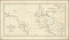
Fine example of the first edition of this rare map of Alaska and vicinity, generally believed to be the earliest printed map Alaska published in America and the only such map published in the 18th Century.
The map was printed in Boston by Spotswood and Nancrede and engraved by Callender, for Malham's The Naval Gazetteer.
The map provides and excellent post-Cook, pre-Vancouver look at the region, delineating the Alleutian Islands and the Coast of Alaska and British Columbia with excellent detail for the period. The map depicts discoveries in the region, including Dixon's voyage of 1787 and the area discovered by Captain Duncan to the north of Middleton's Sound.
The coastline to the north of the Alleutians is still quite conjectural, ending with "Fields and Mountains of Ice" in the northern part of the "Bhering's Straits."
A fine early map, which was revised and re-issued in the 19th Century, with new information from Vancouver, etc.