


|
||

|

|
|

|
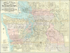
Rare separately issued map of Washington, published in Seattle by the O.P. Anderson Map & Blue Print Co. Inc.
The map provides and exceptional look at the region extending from the Straits of Juan de Fuca to Willapa Harbor in the west and the Slate Creek Mining District in the northwest to the Yakima Indian Reservation in the southeast.
The map provides exceptional topographical detail, focusing in fine detail on the mining regions in the eastern part of the map.
Covers all or parts of Whatcom, Okanogan, San Juan, Skagit, Clallam, Island, Snohomish, Jefferson, Kitsap, King, Kittitas, Douglas, Chehalis, Mason, Thurston, Pierce, Pacific, Lewis, and Yakima counties.
Shows townships, sections, railroads, settlements, Indian reservations, drainage, mining districts, glaciers, etc.
The map is very rare on the market, this being the first example we have ever seen offered for sale.