


|
||

|

|
|

|
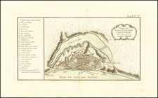
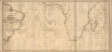
Old color example of Barleus' map of a portion of Brazil, which first appeared in Barleus's rervm per Octennivm in Brasilia et alibi nuper gesterum sub Praefectura Illustrissimi Comitis I. Mavritii, Nassoviae, &c…published by Blaeu in 1647 and later in Blaeu's Atlas Major, from which this example comes.
The Barleus edition of the maps appeared prior to the inclusion of the maps in the Atlas Major and can be distinguished by the lack of text on the verso. This example extends from the Rio San Francisco to the Rio Gujaraigacu.
This series of maps is one of the most coveted of all Brazilian maps from the 17th Century. Highly decorative and very scarce.
Willem Janszoon Blaeu (1571-1638) was a prominent Dutch geographer and publisher. Born the son of a herring merchant, Blaeu chose not fish but mathematics and astronomy for his focus. He studied with the famous Danish astronomer Tycho Brahe, with whom he honed his instrument and globe making skills. Blaeu set up shop in Amsterdam, where he sold instruments and globes, published maps, and edited the works of intellectuals like Descartes and Hugo Grotius. In 1635, he released his atlas, Theatrum Orbis Terrarum, sive, Atlas novus.
Willem died in 1638. He had two sons, Cornelis (1610-1648) and Joan (1596-1673). Joan trained as a lawyer, but joined his father’s business rather than practice. After his father’s death, the brothers took over their father’s shop and Joan took on his work as hydrographer to the Dutch East India Company. Later in life, Joan would modify and greatly expand his father’s Atlas novus, eventually releasing his masterpiece, the Atlas maior, between 1662 and 1672.
![[ Porto Calvo ] Eroberung der Vestung Povacon zu Porto Calvo in Brasilia, durch Graff Joh. Mauritz van Nassau General in Brasilien, im Febuario und Mario Anno 1637 . . .](https://storage.googleapis.com/raremaps/img/small/0325gh.jpg)