|
||

|

|
|

|
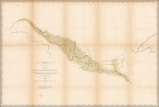
Fascinating and colorful official map of the Chickasaw Indian Territory in Oklahoma.
The present map was issued by the U.S. Geological Survey to depict the large Chickasaw Indian reserve in central-south Oklahoma, located between the Canadian and Red Rivers. A color key to the left of the title designates agricultural (yellow), mountain (pink) and rocky lands (greenish-blue). The territory was given to the Chickasaw Nation as compensation following the Chickasaw's expulsion in the 1830s from their ancestral lands in Tennessee, Alabama and Mississippi. Along with the Cherokee, Choctaw, Muskogee (Creeks) and Seminole Nations, the Chickasaw made up the 'Five Civilized Tribes' who came to occupy large reserves in what was the Indian Territory (Oklahoma). Following the Civil War, the Reconstruction Treaties forced the Chickasaw and the Choctaw Nations, who had supported the Confederacy, to cede their territories in western Oklahoma, eventually creating Oklahoma Territory in 1890 (out of what is now western Oklahoma), while the eastern reserves that remained comprised a reduced Indian Territory.
In 1893, the federal government appointed the Commission to the Five Civilized Tribes in order to negotiate with the Native American nations an arrangement for the extinguishment of their communal land titles title in favor of dividing the reserves amongst individual members of the tribes. This commission became known as the Dawes Commission, after Senator Henry L. Dawes, who was largely responsible for the legislation. Its principal mandate was to make an equitable division of nearly twenty million acres of land among more that 100,000 Indians, so creating a basis for civil government in preparation for Oklahoma to be admitted as a state (through combining the Indian Territory with the Oklahoma Territory). In 1895, the U.S. Geological Survey began to survey all of the lands in the Indian Territory into townships, ranges and sections, along with providing assessments of the economic qualities of these divisions. The resulting maps were then used by the Dawes Commission to assist the citizens on the tribal rolls to select their individual plats of land. Once this process was complete, Oklahoma was admitted as the 46th state in 1907.

![Carte De La Louisiane Et Du Cours Du Mississipi . . . Juin 1718 [1st State!]](https://storage.googleapis.com/raremaps/img/small/59797.jpg)