|
||

|

|
|

|
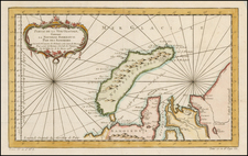
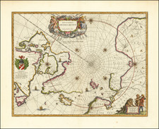
Rare map of part of the Arctic Regions, showing the extent of the Arctic Explorations of Capts. Ross, Parry, & Franklin from 1818 to 1827.
Includes detailed accounts of the various explorer's routes and significant discoveries, along with a large inset of Franklin's Journey from Coppermine Rier to the Head of Bathurst Inset & Return by Hood's River and an inset map of Northern Alaska.
The map provides a fantastic overview of the extent of Arctic exploration through the close of 1827. While the map indicates that it was included in Thomson's General Atlas, the map includes a curious reference to Map 74 for an illustration of the Northwest Passage and a note that it was engraved by Hewitt at Buckingham Place, two notes which are unusual for Thomson's atlases.
Thomson's atlas thrived in the mid 1810s, and we ever seen a post 1825 edition of the atlas on the market, although we have handled editions of the United States map updated to 1832. The manuscript page number in the top margin and extra folds suggests that this map, while ostensibly printed for Thomson's General Atlas, more likely was purchased separately and added to a composite atlas or collection of maps and views as No. 29 in the collection.
We have never before seen the map, although we note one prior example was offered by Kit Kapp in a catalog in 1989.
John Thomson (1777-ca. 1840) was a commercial map publisher active in Edinburgh. He specialized in guide books and atlases and is primarily known for his Atlas of Scotland (1832) and the New General Atlas, first published in 1817 and reissued for the next quarter century. The New General Atlas was a commercial success—it was also published in Dublin and London—and it compiled existing geographic knowledge in compelling ways for a wide audience.
His Atlas of Scotland introduced new geographic information and was the first large-scale atlas of Scotland to be organized by county. It provided the most-accurate view of Scotland available before the Clearances. Work on the atlas began in 1820 and led to Thomson’s bankruptcy in 1830 due to the high costs of gathering the latest surveys and reviewing the required materials. Despite the publication of the atlas, Thomson declared bankruptcy again in 1835.